NATION

PASSWORD

Your nation's climate

A place to put national factbooks, embassy exchanges, and other information regarding the nations of the world. [In character]
User avatar
Republique Nouvelle Navaraise
Bureaucrat
 
Posts: 43
Founded: Feb 07, 2018
Ex-Nation

Your nation's climate

Postby Republique Nouvelle Navaraise » Wed Feb 07, 2018 3:27 am

What is the climate in your nation?

My nation is a big island (the size of Ireland) in the Southern Indian ocean,

The terrain (which is dominated by volcanic plateaus intersected by valleys and coastal plains) affects the climate which is warm temperate (Cfb in the Köppen climate classification). While the climate is humid (never dropping below 30%), there is a noticeable winter maximum to the rainfall and drought occasionally occurs during the summer months. Overall the climate is similar to Northwestern France, expect with milder winters.

The summers are warm, The Mascrene High pressure system dominates the country and most days are sunny. Although there is still some rain coming from cold fronts between the high pressure systems. Average temperatures in January in lower elevations (below 300 m) are between 17-20C. Temperatures seldom exceed 30C, although when it is warm the high humidity makes it feel warmer.

The winters are mild, the Southern Ocean low pressure systems dominate the country and the weather is wet and cloudy. However temperatures are mild, with average July temperatures varying from 7-10C. Also at low elevations temperatures never drop below -5C and snow is an event which only occurs between every 5-20 years.

Annual median rainfall varies from as low as 800 mm to over 2000 mm. The west facing slopes of the mountains receive more than 4000 mm annually. Median annual precipitation days range from 165-220 days.
Last edited by Republique Nouvelle Navaraise on Sat Feb 17, 2018 6:23 am, edited 1 time in total.

User avatar
Radiatia
Powerbroker
 
Posts: 8394
Founded: Oct 25, 2011
Ex-Nation

Postby Radiatia » Wed Feb 07, 2018 4:00 am

Radiatia has an incredibly wide variety of climates due to its large landmass and the fact that it covers multiple latitudes.

Southern Chongluntz is unique in having an Oceanic Climate (Köppen Cfb), while the rest of the peninsula is continental (Köppen Dfb). There is also a mountain range running along the spine of the Chongluntz peninsula which features a number of microclimates.

The central and south-eastern states are arid, mostly prairies and steppes, with the Great Radiatian Desert located in the southeast. (Köppen BSk and BWk).

The western states are mostly humid continental climates (Köppen Dfa or Dfb), while most of the northwest and northern states have a subarctic climate (Köppen Dfc or Dfd).

The far north, particularly Polaris, is mostly tundra (Köppen ET), while the extreme northern parts of Polaris are frozen all year long. (Köppen EF).

The hottest temperature ever recorded in Radiatia was 51°C (123.8°F) at Meramon, Detzertscha.

The coldest temperature ever recorded in Radiatia was -68°C (-90°F) at Baag, Polaris.

Temperatures in most parts of Radiatia are known to be extreme, with some places known to average 40°C (104°F) in Summer and -40°C (-40°F) in Winter. Excluding coastal regions and the Western States, rainfall is usually very low.

Image

User avatar
Republique Nouvelle Navaraise
Bureaucrat
 
Posts: 43
Founded: Feb 07, 2018
Ex-Nation

Postby Republique Nouvelle Navaraise » Wed Feb 07, 2018 4:09 am

Radiatia wrote:
The hottest temperature ever recorded in Radiatia was 51°C (123.8°F) at Meramon, Detzertscha.

The coldest temperature ever recorded in Radiatia was -68°C (-90°F) at Baag, Polaris.

Temperatures in most parts of Radiatia are known to be extreme, with some places known to average 40°C (104°F) in Summer and -40°C (-40°F) in Winter. Excluding coastal regions and the Western States, rainfall is usually very low.


Those are some amazing extremes, my nation's coldest recorded temperature was -10C and the hottest recorded temperature was 35C. Mind you when it is hot, it is quite humid and when it is cold it feels like a lot colder because of the cloud and wind.
Last edited by Republique Nouvelle Navaraise on Wed Feb 07, 2018 4:15 am, edited 1 time in total.

User avatar
Radiatia
Powerbroker
 
Posts: 8394
Founded: Oct 25, 2011
Ex-Nation

Postby Radiatia » Wed Feb 07, 2018 4:12 am

Republique Nouvelle Navaraise wrote:
Radiatia wrote:
The hottest temperature ever recorded in Radiatia was 51°C (123.8°F) at Meramon, Detzertscha.

The coldest temperature ever recorded in Radiatia was -68°C (-90°F) at Baag, Polaris.

Temperatures in most parts of Radiatia are known to be extreme, with some places known to average 40°C (104°F) in Summer and -40°C (-40°F) in Winter. Excluding coastal regions and the Western States, rainfall is usually very low.


Those are some amazing extremes, my nation's coldest temperature recorded was -16C and that was on a mountain 2800 above sea level and the hottest ever recorded temperature was 35C. The vast majority of the country has never gotten below -8C in winter.


Tourist guides tend to warn that Radiatia is the land of "heatstroke and hypothermia".

User avatar
Republique Nouvelle Navaraise
Bureaucrat
 
Posts: 43
Founded: Feb 07, 2018
Ex-Nation

Postby Republique Nouvelle Navaraise » Wed Feb 07, 2018 4:17 am

Radiatia wrote:
Republique Nouvelle Navaraise wrote:
Those are some amazing extremes, my nation's coldest temperature recorded was -16C and that was on a mountain 2800 above sea level and the hottest ever recorded temperature was 35C. The vast majority of the country has never gotten below -8C in winter.


Tourist guides tend to warn that Radiatia is the land of "heatstroke and hypothermia".


That is a good warning.

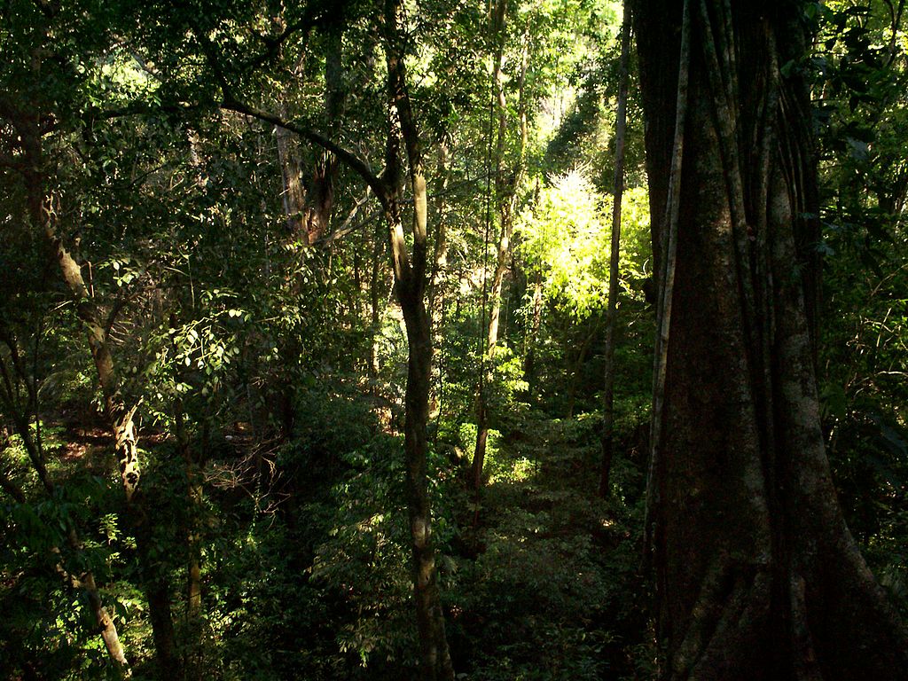
My nation is interesting for having a lot of subtropical vegetation (forests of broad-leaf evergreen trees with fern trees, along with palm trees being grown) for a country with summer temperatures comparable to cool temperature regions.

Also it is a nation because of having some mountains reaching more than 2000 meters high (the highest is 2800 meters high), the tourist guides state than you can surf on the beach and ski on the same day :-D
Last edited by Republique Nouvelle Navaraise on Wed Feb 07, 2018 4:20 am, edited 4 times in total.

User avatar
Gonddor
Attaché
 
Posts: 88
Founded: Jan 27, 2018
Ex-Nation

Postby Gonddor » Wed Feb 07, 2018 4:49 am

Mediterranean in the south and more temperate in the north of Gondor. Gondor's woods are both leaf and needle, and mixed.
Not using NS Stats. Use Policies and my factbooks as reference.

User avatar
Republique Nouvelle Navaraise
Bureaucrat
 
Posts: 43
Founded: Feb 07, 2018
Ex-Nation

Postby Republique Nouvelle Navaraise » Wed Feb 07, 2018 5:11 am

Gonddor wrote:Mediterranean in the south and more temperate in the north of Gondor. Gondor's woods are both leaf and needle, and mixed.

My nation's high altitude forests (between roughly 600-750 meters and 1150-1300 meters above sea level) are an interesting mixture of needle leaf and evergreen broad leaf trees due to both the cool short summers and mild winters in those altitudies. The only needle leaf tree in these forests is a close relative of the Widdringtonia whytei or Mulanje cypress native to the Mulanje Massif of Malawi, although my nation's species of conifer looks more like the Pinus sylvestris or scots pine.

The lowland forests below those altitudes I have mentioned above are a pretty much broad leaf evergreen or laurel forest which roughly look like these forests, complete with fern trees.

Image
Last edited by Republique Nouvelle Navaraise on Wed Feb 07, 2018 5:12 am, edited 2 times in total.

User avatar
Topoliani
Diplomat
 
Posts: 850
Founded: Aug 19, 2017
Father Knows Best State

Postby Topoliani » Wed Feb 07, 2018 8:44 am

Desert, lots of it.

In fact, the reason why we are able to farm and survive is that we just so happened to find a well with 20 years worth of water near an oasis (with even more water).

Rain comes every other month, and when I say "Rain" I mean an occasional sprinkle. Also, it's always 100*F.

Basically, it's a sandy hellish wasteland, but we learned to tolerate it.
Topoliani: A Post-Apoc Medieval Nation in the Levant

I don't use NSstats, nor is this nation a representation of my views.
IC Year: 1210 AD.
Undergoing its third retcon. The third time's the charm, right?

User avatar
Zhouran
Powerbroker
 
Posts: 7998
Founded: Feb 09, 2013
Ex-Nation

Postby Zhouran » Thu Feb 08, 2018 3:35 am

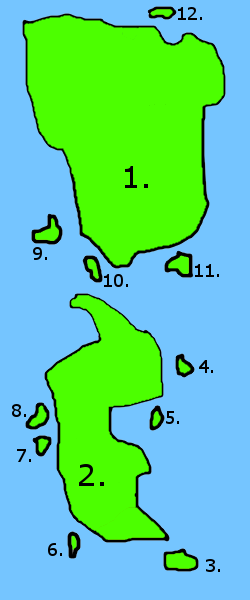
The climate of the Zhournaese archipelago varies. Most of the archipelago has a warm-to-temperate humid continental climate along with a cold semi-arid continental climate in the Northern Zhouranese Grassland, a cold desert climate in the Amunibutakang Desert and a humid subtropical climate in Tanghan, Gongsun and the southern tip of Yongkang.

The island of Yili, along with the northern half of Yongjia, have a temperate humid continental climate that falls under the "Dfb" classification under the Köppen climate classification system. This climate has an average temperature in the warmest month below 25 °C. Summer high temperatures typically average between 24–31 °C during the daytime and the average temperatures in the coldest month are generally far below −5 °C. Frost-free periods typically last 3–5 months. Heat spells lasting over a week are rare. Winters are brisk and cold. Meanwhile the southern half of Yongjia and the majority of Yongkang, as well as the islands of Yilin, Kangyali, Rongyili, Kang, Kangyi, Nang and Jiayi, have a warm humid continental climate that falls under the "Dfa" classification. This climate features an average temperature of at least 25 °C in its warmest month, which is usually July or August. July afternoon temperatures typically average near or slightly above 33 °C while the January mean temperature can be far below −3.0 °C. Frost free periods normally last 5–6 months within this climate regime.


Image
1. Yongjia (Putonghua: 永嘉)

2. Yongkang (Putonghua: 永康)

3. Gongsun (Putonghua: 公孙)

4. Yilin (Putonghua: 艺林)

5. Kangyali (Putonghua: 康亚丽)

6. Tanghan (Putonghua: 淌汗)

7. Rongyili (Putonghua: 荣伊利)

8. Kang (Putonghua: 炕)

9. Kangyi (Putonghua: 康毅)

10. Nang (Putonghua: 馕)

11. Jiayi (Putonghua: 佳艺)

12. Yili (Putonghua: 伊利)


Image
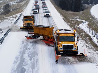
Trucks plowing winter snow on a ring road at the southeastern outskirts of Tanzhou.

Image
People hanging out at a public park in the central-east of Hexie during late spring.

Image
A busy beach in Yanjing's southeastern coastline during mid-summer.

Image
Autumn at a rural town in Kuiwen District, Xingfu Province.

User avatar
Kannabyss
Chargé d'Affaires
 
Posts: 382
Founded: Feb 22, 2016
Ex-Nation

Postby Kannabyss » Thu Feb 08, 2018 9:07 am

Variable. Tropic in the South islands to sub-arctic on the mountaintops in the North.

User avatar
Fatatatutti
Postmaster-General
 
Posts: 10966
Founded: Jun 02, 2006
Ex-Nation

Postby Fatatatutti » Thu Feb 08, 2018 9:47 am

Fatatatutti is right near the equator. On the coast, where most of the people live, the temperature is a steady 26 degrees Celsius all year round. If it drops to 25, people put on sweaters. In the mountains (elevations more than a kilometer) it can get colder at night. During the day there is usually a cool sea breeze and during the night there is usually a warm land breeze, which tend to even things out. It usually only rains at night.

User avatar
Kenmoria
GA Secretariat
 
Posts: 7914
Founded: Jul 03, 2017
Scandinavian Liberal Paradise

Postby Kenmoria » Tue Feb 13, 2018 3:05 am

Kenmoria is rather cold, due to being far away from the tropics. It also rains a lot and occasionally snows in the northern regions. Kenmoria generally fits into the deciduous forests biome because of these characteristics.
Hello! I’m a GAer and NS Roleplayer from the United Kingdom.
My pronouns are he/him.
Any posts that I make as GenSec will be clearly marked as such and OOC. Conversely, my IC ambassador in the General Assembly is Ambassador Fortier. I’m always happy to discuss ideas about proposals, particularly if grammar or wording are in issue. I am also Executive Deputy Minister for the WA Ministry of TNP.
Kenmoria is an illiberal yet democratic nation pursuing the goals of communism in a semi-effective fashion. It has a very broad diplomatic presence despite being economically developing, mainly to seek help in recovering from the effect of a recent civil war. Read the factbook here for more information; perhaps, I will eventually finish it.

User avatar
Arthropol
Minister
 
Posts: 2185
Founded: May 19, 2017
Ex-Nation

Postby Arthropol » Tue Feb 13, 2018 3:14 am

Removed for retcon purposes (2019-08-01)
Last edited by Arthropol on Sun Aug 04, 2019 5:04 pm, edited 1 time in total.
Kingdom of Arthropol - Royaume d'Arthropol
———————————————————————————
Capital: Arthropol City
Language: French
Population: 72 million
Economic: centre-left
Social: moderate
Nationality: Australian
Sex: Male
Economic: fairly left-wing
Social: moderately authoritarian
Not really active on NS forums anymore, still posts once in a while on F&NI and F7. IC views do not represent my real political views. NS stats not used.

User avatar
Olthar
Khan of Spam
 
Posts: 59474
Founded: Jun 23, 2010
Ex-Nation

Postby Olthar » Tue Feb 13, 2018 3:45 am

Olthar is a huge nation that spans an entire continent. Therefore, we have quite a variety of climates.

Southern Olthar tends to have cold winters and hot summers. It sits at both ends of the extremes with little middle ground. Both the highest and lowest temperatures on record happened here. The mountains, however, are cold year round. Precipitation is common in all months with frequent storms and blizzards. Mountain cities often close down for months at a time.

Northern Olthar is more mild and temperate. The summers can sometimes get hot, but snow is rare in winter. It does, however, have troubles with high winds and often tornados due to the land being mostly flat and empty plains. In the past several decades, an initiative to protect the major cities by constructing an artificial mountain range has lead to the desertification of the western half of northern Olthar.

Western Olthar is entirely desert as rain is blocked by the mountain range through central and southern Olthar. The land is almost entirely sand with occasional patches of bare rock. This makes it an ideal place for nuclear testing, especially since the wind patterns simply sweep the fallout radiation out into the ocean where it's no longer our problem. Unrelated, western Olthar is also home to numerous species of mutated saltwater fish. Western Olthar also has one of the world's largest lava plains as the central mountain range contains many volcanoes.

Eastern Olthar is the breadbasket of the nation with many farms and orchards, though the ranches are primarily in northern Olthar. The climate tends to be hot and humid with mild winters. The coast is often. Battered with ocean storms, but further inland tends to be calmer. The many rivers in from central Olthar empty out here, and the eastern side is full of lakes, swamps, and marshes. This helps lead the frequent rain in central and southern Olthar due to the south-west prevailing winds.

Central Olthar is filled with unexplored jungles and forests and is wholly tropical. It rains nearly every day, and hundreds of rivers come down from the mountains. During the spring thaw, large swaths of land on the western side become flooded for up to several months as melted snow pours down from the mountains. Due to the incredible wetness, the humidity in central Olthar is extreme, and it feels like walking through a cloud. Many sections of the jungle are often covered in thick fog, making exploration dangerous.
The Second Cataclysm: My New RP

Roll Them Bones: A Guide to Dice RPs

My mommy says I'm special.
Add 37 to my post count for my previous nation.

Copy and paste this into your signature if you're a unique and special individual who won't conform to another person's demands.

User avatar
Aztlanta
Attaché
 
Posts: 66
Founded: Nov 27, 2017
Ex-Nation

Postby Aztlanta » Fri Feb 23, 2018 6:59 pm
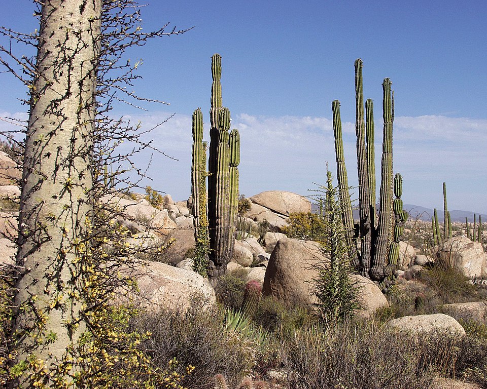
Aztlanta spans the entirety of Mexico, California, and much of Central America. As a result, we are known mostly for our deserts and rainforests.

Image

Image


Our highest recorded natural temperature was a scorching 134°F (56.7°C), in Death Valley, California. While we're not known for our cold weather, California did also reach a record low of -45°F (-43°C).
The Federation of AZTLANTA
A socialist nation consisting of Mexico, California, and Central America, set in an alternate timeline in which Native American civilizations remained mostly isolated from colonial influence.
Aztlanta was founded by the Aztec peoples, and have since become a major player in global politics.

Puppet of Hiachijan. We do not currently use NS stats.

User avatar
AHSCA
Negotiator
 
Posts: 5821
Founded: Mar 08, 2007
Democratic Socialists

Postby AHSCA » Fri Feb 23, 2018 7:29 pm

AHSCA island climate is entirely Tropical monsoonal climate with the Köppen climate classification category "Am" The islands lay primarily on the equator in the regional Inter-tropical Convergence Zone. While the islands see abundant sunshine and annual warm temperatures, it also receives an abundance of thunderstorms year round.

AHSCA's winter months are it's driest but it's summer months see the monsoon season. From the months of Late October-February the monsoon season begins. With it comes a frequency of storms and rough seas. These storms are often very long lasting, very strong, and dump endless amounts of rain on the islands. Lighting is also at it's peak. AHSCA doesn't see many hurricanes during this period but still can receive a few.

In it's dry months, AHSCA sees abundant sunshine but this is also its primary hurricane season. Twenty tropical cyclones enter the AHSCA Area of Responsibility yearly of which ten will be typhoons with five being destructive.

User avatar
Midand
Chargé d'Affaires
 
Posts: 451
Founded: Sep 08, 2017
Democratic Socialists

Postby Midand » Fri Feb 23, 2018 8:01 pm

Midand, which is on the Midandia Island, some few thousand kilometers off of Northern Chile, enjoys tropical or mild temperatures year round.

It gets extremely hot during the summer due to it's proximity to the Equator, though the winter is relatively mild-warm, with cold temperatures being extremely rare.

The driest months, or known among the nation as the Dry Period, lasts from October to February, where little rain falls and temperatures are very hot. The more mild months, from May to August, have more mild temperatures though are still pretty warm. The months in between, March and September, are more of a transition period from the Dry Period to the Mild-Warm Period.
I used to be very active.
Now I grovel all day about how inactive I am.

User avatar
Great Chota
Bureaucrat
 
Posts: 47
Founded: Jun 26, 2016
Ex-Nation

Postby Great Chota » Fri Feb 23, 2018 10:13 pm

Great Chota is entirely landlocked within the Appalachian Mountains, so it depends on where you are.

The lowland parts in the south see fairly hot and humid summers; during this time, temps at Great Tellico, the national capital located on the southern end of the nation (and also nestled in a valley on the foothills), regularly see temps at 30-35C with afternoon thunderstorms most days. Lows are generally at 20C in the mornings, with fog. However, up in the mountains, temperatures are much cooler; Mount Robbins at 1,900 meters up generally sees highs at 20-22C most days, although there too you see thunderstorms.

In then northern parts of the nation, it can get rather cold; Glistening Star University in the north sees temps in the winter generally around 5C for an afternoon high, with lows regularly falling below -10C. Snow isn't uncommon in that part of the nation, whereas in the south, Great Tellico generally only sees 50-100mm of snow per year, where as the north can see upwards of 350-400mm per year.

The warmest temperature ever recorded in the nation was in the very southern part of the nation, as the town of Alexbrough recorded a high of 41C (106F) on July 1, 2012. North Star, the northernmost town in Great Chota, holds the record for lowest temperature in the nation, at -41C (-42F) on December 30, 1917.
Last edited by Great Chota on Sat Feb 24, 2018 1:32 am, edited 2 times in total.

User avatar
Serrey
Political Columnist
 
Posts: 5
Founded: Feb 19, 2018
Ex-Nation

Postby Serrey » Sat Feb 24, 2018 10:37 pm

Temperate broadleaf forest and grasslands. Average annual precipitation of 594mm or 23.4", average temperature of 14°C or 57°F. Low humidity.

User avatar
Hylia Magna
Bureaucrat
 
Posts: 45
Founded: Nov 11, 2017
Ex-Nation

Postby Hylia Magna » Sat Feb 24, 2018 10:52 pm

The majority of the Kingdom lies within temperate ranges, although in the south the climate transitions to subtropical in the coastal areas and semi-arid in the inland south. In the far north west, the mountainous topography and the effects of continentality make it colder on average than the rest of the Kingdom, and the region of Hebra which mostly coincides with that area tends to have the most dramatic ranges of temperatures.

User avatar
Cekoviu
Post Marshal
 
Posts: 16954
Founded: Oct 18, 2017
Ex-Nation

Postby Cekoviu » Sat Feb 24, 2018 11:01 pm

In Cekoviu's AU, which is remarkably similar to the real universe, global warming took effect much earlier, which caused Antarctica to be warmer than it is IRL. Because we're in Antarctica, the day-night cycle is highly variable, and the climate can vary widely from very cold to lukewarm (in summer). Cekoviu is landlocked, and its largest body of water is the Kruşcin Reservoir, which is full of penguin transplants, fish, and other small animals/plants who can live in cold climates. Heaters are often located at the base of stores to melt ice and snow outside. Antarctica is very dry, with not much rainfall, and this is reflected in Cekoviu. The average temperature is -16°C in winter and 20°C in summer.
pro: women's rights
anti: men's rights

User avatar
Higonist
Political Columnist
 
Posts: 2
Founded: Oct 19, 2017
Ex-Nation

Postby Higonist » Sat Feb 24, 2018 11:03 pm

Due to its size and its varied and wide ranging geographical features the lands encompassing the Higonist Empire exhibit almost all possible climates. Furthermore the Higonist Empire as a result can be classified as mega-diverse.

Highest Recorded Temperature: 64 Celsius (147.2 Fahrenheit).

Lowest Recorded Temperature: -93 Celsius (-135.5 Fahrenheit).

2nd Planet Halciyon
In some of the most remote and largely undisturbed regions of Halciyon the flora and fauna species are ancient and even pre-historic in origin and have survived until the present.

The highest officially recorded temperature on Halciyon is 70 degrees Celsius (158.2 Fahrenheit).

The lowest is recorded temperature was measured at -117 degrees Celsius (-178.9 Fahrenheit).

3rd Planet Varija
Overall Variya closely resembles the Caribbean and Pacific islands, Brazil, Indonesia and Thailand.

The highest officially recorded temperature on Variya is 87 degrees Celsius (188.6 Fahrenheit).

The lowest is recorded temperature was measured at -3 degrees Celsius (26 Fahrenheit).

4th Planet Nyrja
Nyrja closely resembles Greenland and Iceland, Canada, Russia as well as both Northern and Central Europe.

The highest officially recorded temperature on Nyrja is 27 degrees Celsius ( 80.6 Fahrenheit).

The lowest is recorded temperature was measured at -125 degrees Celsius (-193 Fahrenheit).

User avatar
The Islands of Versilia
Minister
 
Posts: 2909
Founded: Feb 21, 2016
Ex-Nation

Postby The Islands of Versilia » Sun Feb 25, 2018 4:34 am

Versilia has a mostly temperate climate, with a climate similar to Hokkaido. August is the hottest month, with an average of 21 Celsius. The coldest is January, with an average of -5 Celsius.
STÓRRIKIT VÆRSLAND
FactbooksThemesThe User

Palaeolithic and Bronze Age-inspired FanT-MT civilization of humans and vampiresque hominins living peacefully together in a habitable Greenland presided over by a semi-elective phylarchic monarchy with an A S C E N D E D vampiric hominin from Georgia as queen.
Rate me as Prime Minister

User avatar
Hippie Kiwis
Minister
 
Posts: 2721
Founded: Jan 31, 2014
Father Knows Best State

Postby Hippie Kiwis » Tue Feb 27, 2018 9:36 am

Mediterranean to arctic
This place is not a place of honor... no highly esteemed deed is commemorated here... nothing valued is here. What is here was dangerous and repulsive to us.
The danger is in a particular location... it increases towards a center... the center of danger is here... of a particular size and shape, and below us.
The danger is still present, in your time, as it was in ours. The danger is to the body, and it can kill. The form of the danger is an emanation of energy.
The danger is unleashed only if you substantially disturb this place physically. This place is best shunned and left uninhabited.

User avatar
British Dominions
Bureaucrat
 
Posts: 44
Founded: Feb 27, 2018
Ex-Nation

Postby British Dominions » Tue Feb 27, 2018 12:48 pm

That depends where in the nation you are! As we have territory all over the globe (from Formosa to the Gold Coast, from Arabia to the British Isles, and from the Indian Ocean to the West Indies) we also have a wide range of climates.
--- The Union of British Dominions ---

Next

Advertisement

Remove ads

Return to Factbooks and National Information

Who is online

Users browsing this forum: A m e n r i a, Marquesan, Yahoo [Bot]

Advertisement

Remove ads