NATION

PASSWORD

Map Request Thread

A place to put national factbooks, embassy exchanges, and other information regarding the nations of the world. [In character]

Advertisement

Remove ads

User avatar
Antwhen
Lobbyist
 
Posts: 18
Founded: Oct 16, 2016
Ex-Nation

Postby Antwhen » Wed Oct 19, 2016 3:29 pm

http://imgur.com/dHBYGNe

Can someone please make a really vivid political map of my nation? It's about where the shapes are on my rough draft, but it's all subject to change. I can talk to you more through telegrams if you need clarification or to work out the map. Thank you! :blush:

User avatar
Almonaster Nuevo
Negotiator
 
Posts: 6844
Founded: Mar 11, 2007
Civil Rights Lovefest

Postby Almonaster Nuevo » Fri Oct 21, 2016 11:03 am

Antwhen wrote:http://imgur.com/dHBYGNe

Can someone please make a really vivid political map of my nation? It's about where the shapes are on my rough draft, but it's all subject to change. I can talk to you more through telegrams if you need clarification or to work out the map. Thank you! :blush:


What (if any) information from the RL underlay are you wanting to include?
What is the name of the central city? Are there others to be included?
What is the significance of the red and blue areas? Are there any subdivisions to show?
Do you want any of the surrounding areas labelled?
Christian Democrats wrote:Would you mind explaining what's funny? I'm not seeing any humor.
The Blaatschapen wrote:I'll still graze the forums with my presence
Please do not TG me about graphics requests. That's what the threads are there for.

User avatar
Karjamaa
Spokesperson
 
Posts: 141
Founded: Sep 24, 2016
Ex-Nation

Postby Karjamaa » Fri Oct 21, 2016 1:15 pm

Here
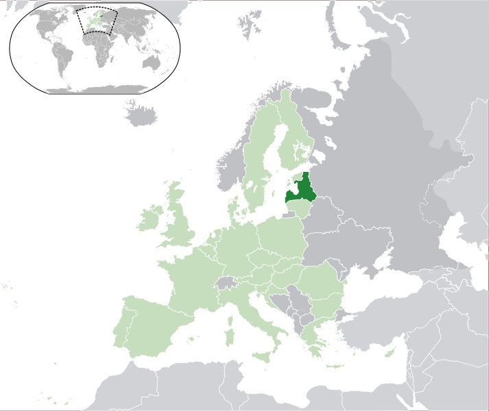
Can I just have south and east Estonia added in the same green color as Latvia. You don't have to change the upper left map.
Last edited by Karjamaa on Sat Oct 22, 2016 2:00 am, edited 1 time in total.
this nation is not finnish. this nation is based on some of my rl views
Nacionālistiska Ganavas Republika
News: Navy to perform large naval  exercise in the Baltic Sea - Defence Minister signs anti-agression pact with Russia - 5 skyscrapers planned to be built in central Juurista - Drug runners caught at the Russian border - 12 citizens dead in train crash in Jurmala
Karjamaa Is A Nation Located Roughly In Estonia And Latvia, And Have A Strong Military Tradition.We Do NOT Use NS Stats

User avatar
Almonaster Nuevo
Negotiator
 
Posts: 6844
Founded: Mar 11, 2007
Civil Rights Lovefest

Postby Almonaster Nuevo » Sat Oct 22, 2016 3:23 am

Karjamaa wrote:Here
Can I just have south and east Estonia added in the same green color as Latvia. You don't have to change the upper left map.


Image
Christian Democrats wrote:Would you mind explaining what's funny? I'm not seeing any humor.
The Blaatschapen wrote:I'll still graze the forums with my presence
Please do not TG me about graphics requests. That's what the threads are there for.

User avatar
Karjamaa
Spokesperson
 
Posts: 141
Founded: Sep 24, 2016
Ex-Nation

Postby Karjamaa » Sat Oct 22, 2016 4:40 am

Almonaster Nuevo wrote:
Karjamaa wrote:Here
Can I just have south and east Estonia added in the same green color as Latvia. You don't have to change the upper left map.


Image

Oh right, I forgot to mention that I want that border line removed, other than that, Thanks!
this nation is not finnish. this nation is based on some of my rl views
Nacionālistiska Ganavas Republika
News: Navy to perform large naval  exercise in the Baltic Sea - Defence Minister signs anti-agression pact with Russia - 5 skyscrapers planned to be built in central Juurista - Drug runners caught at the Russian border - 12 citizens dead in train crash in Jurmala
Karjamaa Is A Nation Located Roughly In Estonia And Latvia, And Have A Strong Military Tradition.We Do NOT Use NS Stats

User avatar
Almonaster Nuevo
Negotiator
 
Posts: 6844
Founded: Mar 11, 2007
Civil Rights Lovefest

Postby Almonaster Nuevo » Mon Oct 24, 2016 5:40 pm

Karjamaa wrote:Oh right, I forgot to mention that I want that border line removed, other than that, Thanks!


Image
Christian Democrats wrote:Would you mind explaining what's funny? I'm not seeing any humor.
The Blaatschapen wrote:I'll still graze the forums with my presence
Please do not TG me about graphics requests. That's what the threads are there for.

User avatar
Yatzatz
Diplomat
 
Posts: 920
Founded: Jul 26, 2016
Ex-Nation

Postby Yatzatz » Wed Oct 26, 2016 12:41 am

My map is in my factbook. Can you make it look real? The triangle-shaped island in the north is all forest, the northeastern tip of the southeastern island is mountains, and the northeast island is extremely varied.
Hi!
Yatzatz is a tropical North Pacific nation. RP population is about 25 million.
The noblest of all dogs is the hot dog; it feeds the hand that bites it. -Laurence J. Peter
Outside of a dog, a book is man's best friend. Inside of a dog, it's too dark to read. -Groucho Marx
I must study politics and war that my sons may have liberty to study mathematics and philosophy. -John Adams
Hanging is too good for a man who makes puns; he should be drawn and quoted. -Fred Allen

Creator of NS Alternate WW2, a historical-based WW2 with NS countries thrown in.

User avatar
Mapleston
Attaché
 
Posts: 79
Founded: Aug 03, 2013
Ex-Nation

Postby Mapleston » Wed Oct 26, 2016 1:47 am

Could someone please make a map of my country (Mapleston) that looks similar to this
Image

Here's our regional map btw:
http://i.imgur.com/KbN5Hza.png

If you have any questions regarding this application, or about Mapleston in general, just shoot me a TG. Cheers!
Last edited by Mapleston on Wed Oct 26, 2016 1:53 am, edited 3 times in total.
MAPLESTON
Glorious and free | Glorieuse et libre


CAMPAIGN RIBBONS

NEWERUSEA
MOSEICA

User avatar
New Astergea
Spokesperson
 
Posts: 128
Founded: Oct 22, 2016
Ex-Nation

Map For New Astergea

Postby New Astergea » Wed Oct 26, 2016 7:23 am

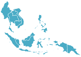
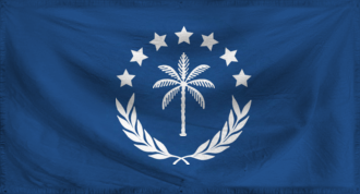
Hello,I'd like to request a world map(?)(i think thats what its called?) in vector form that highlights in my flags blueish color South East Asia from
Myanmar
Thailand
Vietnam
Cambodia
Laos
Philippines
Malaysa
Indonesia
Singapore
Timor-Leste
Andaman and Nicobar Islands
Christmas Islands
Papa New Guinea
Solomon Islands
Fiji Islands
Vanuatu
New Caledonia

Something like this Image but with the globe thing as well as the respective other islands and places i mentioned above?
Thank you! I might request more maps in the future but currently just these few for the sake of my wip factbook :D!
Founder and Member of SEMDA


PMT/FT
Heads of State and Government - Grand Prince Nathan von Rosenwald and Princess-Regent Wendy 'Thet Oo' Khin von Rosenwald
Capital - Astergea City,New Astergea
Class A5: Tier 1, Type IV, Planetary Power - The Civilization Index
Tier 9 - Wise Wanderer(FT), Level 10 - Terrible Titan, Type 6 - Planetary Politician - Yet Another Civilization Index

Current Stance on Pornography and its legality in New Astergea

For those of you who say,"Overpopulation is a myth. You can fit everyone into XX" Please re-think the value of your life. Do you honestly expect everyone to live in one big fuck of a place?

User avatar
Fahshist Yuflijan
Spokesperson
 
Posts: 145
Founded: Oct 13, 2016
Ex-Nation

Postby Fahshist Yuflijan » Wed Oct 26, 2016 8:16 am

Hello, I was wonder if someone could make me a map.

I would like six islands each around the size of Scotland or England in the North West Pacific, near Kamchatka and Japan.
And I would like about half of Eurasia in the same colour as the islands, and this nation controls Eurasia up to the Urals, and the Dead Sea. I would like the colour of Yuflija territory in dark orange, like my flag.
The rest of Europe (including the British isles) and North Africa will be labeled Nazi Germany and in Nazi Red.
The USA controls all US territories at the time of WWII + Australia and South Africa.

If this is too much, my apologies.
Yuflijan is an FMT/PMT superstate located in a 1984-esque world ruled by Fascist vampires. This nation is Atheistic, majorly Vampiric, likes gaining resources and new tech. The year is currently 1985.


We don't use NS stats.

User avatar
Altiros
Political Columnist
 
Posts: 2
Founded: Sep 06, 2016
Ex-Nation

Postby Altiros » Wed Oct 26, 2016 8:23 am

Is anyone willing to make a non-earth map for my fantasy region? If so, I'll provide the requested details. Thanks in advance
The High Kingdom of Altiros
WA Delegate and High Lady of The United Rogue Nations of Alteria, a high fantasy region full of caring friends and daring foes.

User avatar
Altiros
Political Columnist
 
Posts: 2
Founded: Sep 06, 2016
Ex-Nation

Postby Altiros » Thu Oct 27, 2016 8:41 pm

Bump?
The High Kingdom of Altiros
WA Delegate and High Lady of The United Rogue Nations of Alteria, a high fantasy region full of caring friends and daring foes.

User avatar
Fahshist Yuflijan
Spokesperson
 
Posts: 145
Founded: Oct 13, 2016
Ex-Nation

Postby Fahshist Yuflijan » Fri Oct 28, 2016 2:09 pm

Bump.
Yuflijan is an FMT/PMT superstate located in a 1984-esque world ruled by Fascist vampires. This nation is Atheistic, majorly Vampiric, likes gaining resources and new tech. The year is currently 1985.


We don't use NS stats.

User avatar
Konarus
Envoy
 
Posts: 227
Founded: Jan 10, 2016
Ex-Nation

Postby Konarus » Fri Oct 28, 2016 2:14 pm

.
Proud Member of the SOPWHKTNTPBHNIWTP
IRL PROs and ANTIs

PRO
Pro-LGBT, Pro-Gun, Pro-Life, Palestine, Socio-Capitalism, Kasich, The Donald

ANTI
Despotism, Syria, Israel, North Korea, Stupidity, Westboro Baptism, Hillary

Bits: I am a 15 year old, wehraboo, conspiracy theorist, paranoid, animal loving, military interested, conservative leaning twit.

Economic Left/Right: 1.63
Social Libertarian/Authoritarian: 5.74
NS stats are burrshit

OOC News: Nation and nation factbooks are undergoing massive revamp.

User avatar
Corindia
Minister
 
Posts: 2669
Founded: May 29, 2016
Left-wing Utopia

Postby Corindia » Fri Oct 28, 2016 2:30 pm

Mapleston wrote:Could someone please make a map of my country (Mapleston) that looks similar to this
(Image)

Here's our regional map btw:
http://i.imgur.com/KbN5Hza.png

If you have any questions regarding this application, or about Mapleston in general, just shoot me a TG. Cheers!

http://planetmaker.wthr.us/#

http://i.imgur.com/REeWXlV.png

Of the People, For the People

User avatar
Kovanica
Political Columnist
 
Posts: 2
Founded: Oct 26, 2016
Ex-Nation

Postby Kovanica » Fri Oct 28, 2016 2:31 pm

http://www.nationstates.net/nation=kova ... /id=712863

^ Some examples of my work. Occasionally I may be willing to make maps of a similar style to those above. I've already got a request from somewhere else waiting at the moment though, so don't expect much from me in a while. I guess I'm more if you want reletively good quality maps fast (depending on how much I've got in the que, probably the day it's requested, maybe the day after).

What in willing to do:
    Maps in the style as seen in the factbook above
    Naming major cities on similar maps to those in the factbook above
    Drawing state, province, district, etc borders on similar maps to those above
    Labelling the capital, cities of those districts, states, etc.

Please don't give me 100 state borders to draw up, I won't take that sort of request. I do this because I enjoy it and it makes me feel useful, and stuff like that takes out the fun aspect.
Last edited by Kovanica on Fri Oct 28, 2016 2:36 pm, edited 2 times in total.

User avatar
Yatzatz
Diplomat
 
Posts: 920
Founded: Jul 26, 2016
Ex-Nation

Postby Yatzatz » Mon Oct 31, 2016 1:22 pm

Yatzatz wrote:My map is in my factbook. Can you make it look real? The triangle-shaped island in the north is all forest, the northeastern tip of the southeastern island is mountains, and the northeast island is extremely varied.

Bump.
Hi!
Yatzatz is a tropical North Pacific nation. RP population is about 25 million.
The noblest of all dogs is the hot dog; it feeds the hand that bites it. -Laurence J. Peter
Outside of a dog, a book is man's best friend. Inside of a dog, it's too dark to read. -Groucho Marx
I must study politics and war that my sons may have liberty to study mathematics and philosophy. -John Adams
Hanging is too good for a man who makes puns; he should be drawn and quoted. -Fred Allen

Creator of NS Alternate WW2, a historical-based WW2 with NS countries thrown in.

User avatar
New Astergea
Spokesperson
 
Posts: 128
Founded: Oct 22, 2016
Ex-Nation

Postby New Astergea » Tue Nov 01, 2016 4:24 am

New Astergea wrote:Hello,I'd like to request a world map(?)(i think thats what its called?) in vector form that highlights in my flags blueish color South East Asia from
Myanmar
Thailand
Vietnam
Cambodia
Laos
Philippines
Malaysa
Indonesia
Singapore
Timor-Leste
Andaman and Nicobar Islands
Christmas Islands
Papa New Guinea
Solomon Islands
Fiji Islands
Vanuatu
New Caledonia

Something like this (Image) but with the globe thing as well as the respective other islands and places i mentioned above?
Thank you! I might request more maps in the future but currently just these few for the sake of my wip factbook :D!


Bump
Founder and Member of SEMDA


PMT/FT
Heads of State and Government - Grand Prince Nathan von Rosenwald and Princess-Regent Wendy 'Thet Oo' Khin von Rosenwald
Capital - Astergea City,New Astergea
Class A5: Tier 1, Type IV, Planetary Power - The Civilization Index
Tier 9 - Wise Wanderer(FT), Level 10 - Terrible Titan, Type 6 - Planetary Politician - Yet Another Civilization Index

Current Stance on Pornography and its legality in New Astergea

For those of you who say,"Overpopulation is a myth. You can fit everyone into XX" Please re-think the value of your life. Do you honestly expect everyone to live in one big fuck of a place?

User avatar
Antwhen
Lobbyist
 
Posts: 18
Founded: Oct 16, 2016
Ex-Nation

Postby Antwhen » Tue Nov 01, 2016 2:49 pm

Almonaster Nuevo wrote:
What (if any) information from the RL underlay are you wanting to include?
What is the name of the central city? Are there others to be included?
What is the significance of the red and blue areas? Are there any subdivisions to show?
Do you want any of the surrounding areas labelled?


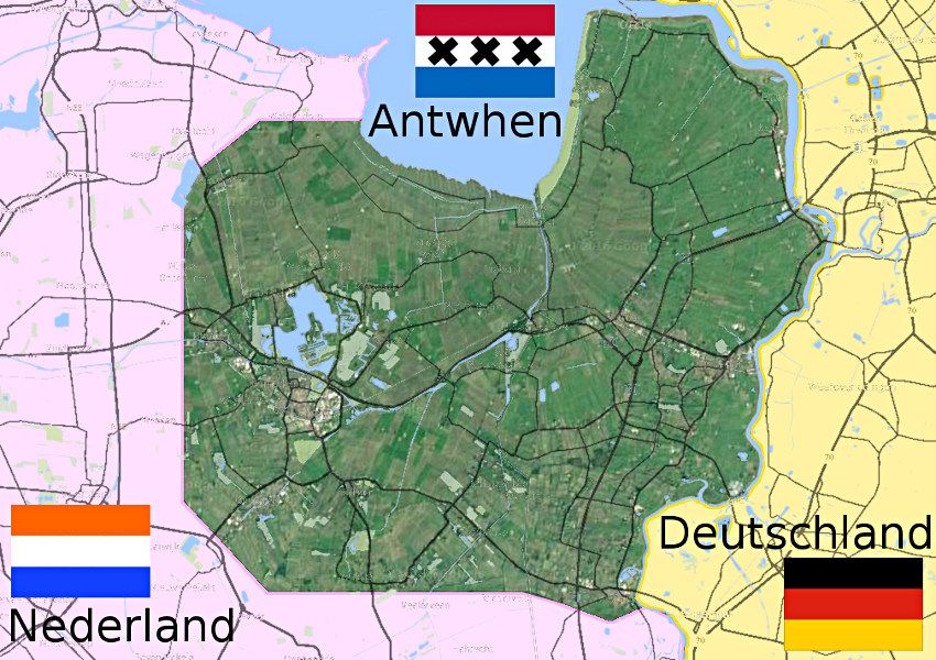
Ah sorry this is so late! Um I really don't need any info other than the general area its in
My nation is a city state, so there's really only one city to include.
The red and blue areas don't really mean anything, I did this on [url]thetruesizeof.com[/url], so it's just due to the constraints of the system lol
Um nothing other than labeling the bit left of my country as the netherlands and the bit right of my country as germany.
Again, sorry this took so long! If you want more info, you can always telegram me! :)

User avatar
Yatzatz
Diplomat
 
Posts: 920
Founded: Jul 26, 2016
Ex-Nation

Postby Yatzatz » Sun Nov 13, 2016 10:48 am

Yatzatz wrote:
Yatzatz wrote:My map is in my factbook. Can you make it look real? The triangle-shaped island in the north is all forest, the northeastern tip of the southeastern island is mountains, and the northeast island is extremely varied.

Bump.

Bump again.
Hi!
Yatzatz is a tropical North Pacific nation. RP population is about 25 million.
The noblest of all dogs is the hot dog; it feeds the hand that bites it. -Laurence J. Peter
Outside of a dog, a book is man's best friend. Inside of a dog, it's too dark to read. -Groucho Marx
I must study politics and war that my sons may have liberty to study mathematics and philosophy. -John Adams
Hanging is too good for a man who makes puns; he should be drawn and quoted. -Fred Allen

Creator of NS Alternate WW2, a historical-based WW2 with NS countries thrown in.

User avatar
Almonaster Nuevo
Negotiator
 
Posts: 6844
Founded: Mar 11, 2007
Civil Rights Lovefest

Postby Almonaster Nuevo » Mon Nov 14, 2016 2:08 pm

Antwhen wrote:http://imgur.com/dHBYGNe

Can someone please make a really vivid political map of my nation? It's about where the shapes are on my rough draft, but it's all subject to change. I can talk to you more through telegrams if you need clarification or to work out the map. Thank you! :blush:


Image
Christian Democrats wrote:Would you mind explaining what's funny? I'm not seeing any humor.
The Blaatschapen wrote:I'll still graze the forums with my presence
Please do not TG me about graphics requests. That's what the threads are there for.

User avatar
Fahshist Yuflijan
Spokesperson
 
Posts: 145
Founded: Oct 13, 2016
Ex-Nation

Postby Fahshist Yuflijan » Fri Nov 18, 2016 1:51 pm

Bump.
Fahshist Yuflijan wrote:Hello, I was wonder if someone could make me a map.

I would like six islands each around the size of Scotland or England in the North West Pacific, near Kamchatka and Japan.
And I would like about half of Eurasia in the same colour as the islands, and this nation controls Eurasia up to the Urals, and the Dead Sea. I would like the colour of Yuflija territory in dark orange, like my flag.
The rest of Europe (including the British isles) and North Africa will be labeled Nazi Germany and in Nazi Red.
The USA controls all US territories at the time of WWII + Australia and South Africa.

If this is too much, my apologies.
Yuflijan is an FMT/PMT superstate located in a 1984-esque world ruled by Fascist vampires. This nation is Atheistic, majorly Vampiric, likes gaining resources and new tech. The year is currently 1985.


We don't use NS stats.

User avatar
Almonaster Nuevo
Negotiator
 
Posts: 6844
Founded: Mar 11, 2007
Civil Rights Lovefest

Postby Almonaster Nuevo » Sat Nov 19, 2016 10:45 am

Please don't bump. It clutters up the thread and makes it harder to find requests.

(For myself, I'm unlikely to be doing much map-making in the near future. Just the way of it, sorry.)
Christian Democrats wrote:Would you mind explaining what's funny? I'm not seeing any humor.
The Blaatschapen wrote:I'll still graze the forums with my presence
Please do not TG me about graphics requests. That's what the threads are there for.

User avatar
Antwhen
Lobbyist
 
Posts: 18
Founded: Oct 16, 2016
Ex-Nation

Postby Antwhen » Tue Nov 22, 2016 9:32 pm

Almonaster Nuevo wrote:
Antwhen wrote:http://imgur.com/dHBYGNe

Can someone please make a really vivid political map of my nation? It's about where the shapes are on my rough draft, but it's all subject to change. I can talk to you more through telegrams if you need clarification or to work out the map. Thank you! :blush:


Image


That looks fantastic! Thank you so much!

User avatar
Yatzatz
Diplomat
 
Posts: 920
Founded: Jul 26, 2016
Ex-Nation

Postby Yatzatz » Thu Dec 22, 2016 4:23 am

Yatzatz wrote:My map is in my factbook. Can you make it look real? The triangle-shaped island in the north is all forest, the northeastern tip of the southeastern island is mountains, and the northeast island is extremely varied.

Bump.
Hi!
Yatzatz is a tropical North Pacific nation. RP population is about 25 million.
The noblest of all dogs is the hot dog; it feeds the hand that bites it. -Laurence J. Peter
Outside of a dog, a book is man's best friend. Inside of a dog, it's too dark to read. -Groucho Marx
I must study politics and war that my sons may have liberty to study mathematics and philosophy. -John Adams
Hanging is too good for a man who makes puns; he should be drawn and quoted. -Fred Allen

Creator of NS Alternate WW2, a historical-based WW2 with NS countries thrown in.

PreviousNext

Advertisement

Remove ads

Return to Factbooks and National Information

Who is online

Users browsing this forum: Hyperterra, Marquesan, Shearoa

Advertisement

Remove ads