


RECOANISSANCE DRONE MK-14F "HINGABANA"
Price: N$D 50 000
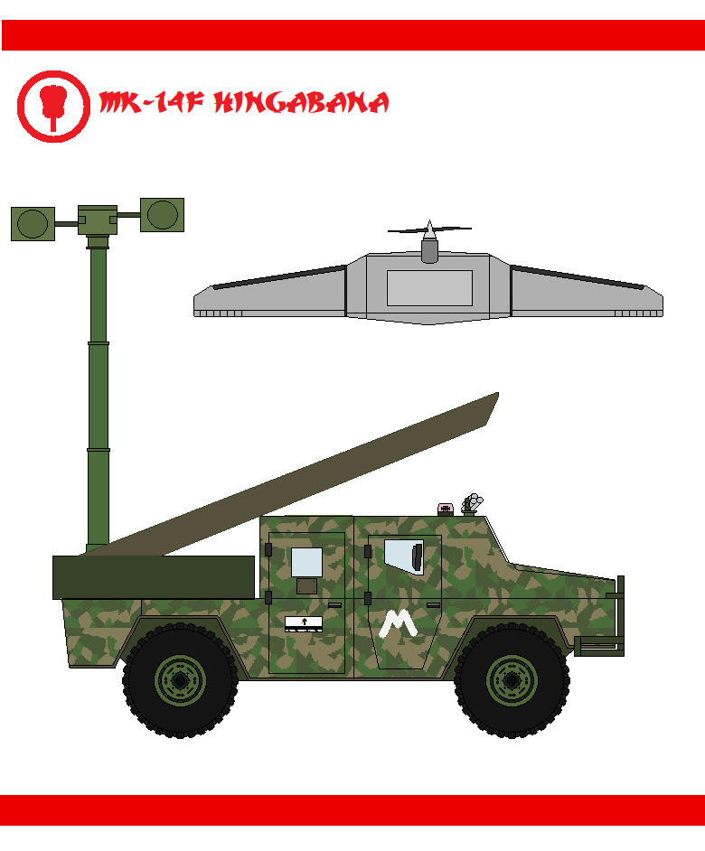
Fujita MK-14F, nicknamed "Higabana" ("Red Spider Lilly") is a unmanned Aerial vehicle from the Holy Nifonese Empire. The goal of the vehicle is long range surveilance of variety of objects. It can also be used for artillery fire control, border patrol or signals intelligence.
- The drone is arranged in a flying wing design.
- The wingspan of the wing is 320 centimeters, while the body length is 50 centimeters long.
- The wings are folding to ease the transport of the device.
- Majority of the body has been built out of high- quality composites.
- Two vertical stabilizers have been mounted on the bottom of the aircraft.
- Empty weight 15 kilograms.
- Up to 3 kilograms of mission payload can be carried.
- The drone is launched via a steam catapult.
- Recovery via parachute.
- Responsible for propulsion is a 60N Kojima KI-7 turbine engine using kerosene fuel.
- The engine powers a two blade puller propeller.
- Parts of the engine and propeller were 3D printed to lower the costs.
- Flight time 4 hours.
- Maximum communications range 100 kilometers.
- Capability to remain in the air for 4 hours.
- Up to 110 km/h can be reached during a flight.
- Service celling 3000 meters.
- The drone can operate from -45*C to 50*C.
- Stability in bad weather conditions.
- Optronic unit can be switched per client's demands.
- The base model contains gimbal-stabilised Washi DU7 unit, with 360* degree of rotation. The unit contains:
* WY-551 camera with 30x zoom and digital 6x zoom; which equals total zoom capbility of 180x. The operator can trap the camera on an element by tapping it on the control tablet. Field of view is 64*. Images and videos can be produced in resolution of 1920x1080px.
* WT-99 thermal imaging camera capable of developing IR images at 620x 256px.
* Laser rangefinder.
* AI based automatic target recognition & tracking algorythms.
- Using the captured the images the drone can create 3D maps of surveyed areas.
- Possiblity to integrate a gas sensor or ELINT equipment.
- Intertial navitagion via laser-ring gyroscope coupled with AXISAT GNSS. Additionally, should the GNSS be lost, the drone uses an AI - based system allowing it to photoreference images for orientation.
- Advanced mission computer allows the drone to fly along pre-programmed routes without operator input, thus decreasing the vunerability to EW. The drone can be programmed to fly over a position, record the video and return autonomosly.
- The drone receives commands via a Ku-Band datalink; transmits images on the VHF frequency.
- Hingabana can start and fly without transmitting any data, preventing enemy EW from detecting it.
- Control is done with joystick and a tablet.
- The crew sits in a modified Type 2005 vehicle, which features the catapult, operator's station and mission computers. The vehicle features also a ready radio antenna, thus allowing the drone to be launched withi 2 minutes from the march.

