Urban Planning in YN
Does your nation implement any specific form of urban planning? Do any towns or cities in your nation follow a set standard of urban planning? Is the goal of urban planning in your nation based on maximizing efficiency or conforming to a set form of totalitarian social-engineering?
The Zhouranese Cityscape/Townscape Model was created in early 1937. While the cityscape/townscape of each city/town can differ, the model refers to a general design that reflects a nationalist vision to boost public morale and display national wealth and pride.
Within the central area of a city/town, major roads would generally follow a wheel-and-spoke pattern. There would be an abundance of geometric patterns, including concentric hexagonal and octagonal streets emanating from several radii. The central area would contain various public buildings as well as ornamental monuments, parks and open spaces. Connecting the central area would be a vast array of more parks, open spaces, public buildings and monuments, flanked by wide avenues and boulevards. The cityscape/townscape model features a complex system of roads, ring roads, road tunnels and highways.
The central area would be organized along a central grand boulevard that would generally serve as a parade ground, which would result in the boulevard being closed off to traffic during occasions. Vehicles would instead be diverted into underground roads running directly underneath the parade route. The grand boulevard would run from north to south through the heart of a city/town.
Within the outer areas of a city/town, outside the central area, streets are generally laid out in a north-south, east-west grid, giving an orderly appearance.
The outer areas would be organized into a hierarchy of city/town districts (semi-self-contained residential areas), city/town centres (commercial and political centres), community centres (commercial and community areas), local suburbs (self-sufficient neighborhoods) and industrial areas. Although these divisions have no formal role in the governance or administration of a city/town, they would form a basis for urban planning and development. City/town districts, city/town centres, community centres, local suburbs and industrial areas all have similar sets of public amenities.
Communal Self-Sufficiency
As part of the model, each area in a town or city such as neighborhoods and industrial areas are designed to maximize productive efficiency and maintain a high-level of communal self-sufficiency. Within the model, self-sufficient urban neighborhoods feature numerous amenities including grocery stores, barber shops, general stores, restaurants, shopping arcades, fitness centers, retail shops, convenience stores, coffeehouses and dining outlets, entertainment facilities, leisure areas, clinics, post offices, a library and others, while self-sufficient suburban neighborhoods on the other hand feature a set of amenities including grocery stores, barber shops, general stores, restaurants, shopping malls and strip malls behind large parking lots, fitness centers, retail shops, convenience stores, coffeehouses and dining outlets, entertainment facilities, leisure areas, clinics, post offices, schools, a library and others. Apart from residential housing complexes, self-sufficient urban neighborhoods also contain mixed-use business and commercial buildings, landscaped areas and parks, walkways, plazas and courtyards, while self-sufficient suburban neighborhoods feature mixed-use business and commercial buildings, landscaped areas and parks, botanical gardens, plazas, courtyards, zoning patterns that separate residential and commercial development, and a road network designed to conform to a hierarchy, including culs-de-sac, leading to larger residential streets, in turn leading to large collector roads. The entire purpose of these geographically localized self-sufficient urban/suburban communities is to simply increase social cohesion among the communities and create a sense of communal spirit among the inhabitants since communal collectivism is an important value within Zhouranese society.
Apart from neighborhoods, the Zhouranese cityscape/townscape model also features other self-sufficient areas such as scientific research zones and retail business zones, thus fully-maximizing social mobility and national productivity among each town and city.
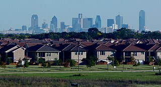
Rows of suburban houses at a self-sufficient suburban neighborhood in the northeastern outskirts of Kuizhou with the city skyline seen in the background

Office buildings at an economic business zone in the southwestern outskirts of Anjing at night

A retail shop at a self-sufficient suburban neighborhood in the eastern outskirts of Ouyang
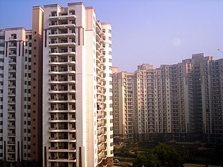
An apartment complex at a self-sufficient urban neighborhood in the western outskirts of Hexie

A large shopping mall at a multipurpose urban zone in the west of Tanzhou

Multiple mid-rise apartment buildings at a self-sufficient suburban neighborhood in the northern outskirts of Liao

A view of an office building inside a scientific research zone in the southern outskirts of Jingnan

Big box shopping centers at a self-sufficient suburban neighborhood in the northeastern outskirts of Hexie

A dining outlet and various retail buildings at a self-sufficient suburban neighborhood in the northwestern outskirts of Tanzhou
Within the central area of a city/town, major roads would generally follow a wheel-and-spoke pattern. There would be an abundance of geometric patterns, including concentric hexagonal and octagonal streets emanating from several radii. The central area would contain various public buildings as well as ornamental monuments, parks and open spaces. Connecting the central area would be a vast array of more parks, open spaces, public buildings and monuments, flanked by wide avenues and boulevards. The cityscape/townscape model features a complex system of roads, ring roads, road tunnels and highways.
The central area would be organized along a central grand boulevard that would generally serve as a parade ground, which would result in the boulevard being closed off to traffic during occasions. Vehicles would instead be diverted into underground roads running directly underneath the parade route. The grand boulevard would run from north to south through the heart of a city/town.
Within the outer areas of a city/town, outside the central area, streets are generally laid out in a north-south, east-west grid, giving an orderly appearance.
The outer areas would be organized into a hierarchy of city/town districts (semi-self-contained residential areas), city/town centres (commercial and political centres), community centres (commercial and community areas), local suburbs (self-sufficient neighborhoods) and industrial areas. Although these divisions have no formal role in the governance or administration of a city/town, they would form a basis for urban planning and development. City/town districts, city/town centres, community centres, local suburbs and industrial areas all have similar sets of public amenities.
Communal Self-Sufficiency
As part of the model, each area in a town or city such as neighborhoods and industrial areas are designed to maximize productive efficiency and maintain a high-level of communal self-sufficiency. Within the model, self-sufficient urban neighborhoods feature numerous amenities including grocery stores, barber shops, general stores, restaurants, shopping arcades, fitness centers, retail shops, convenience stores, coffeehouses and dining outlets, entertainment facilities, leisure areas, clinics, post offices, a library and others, while self-sufficient suburban neighborhoods on the other hand feature a set of amenities including grocery stores, barber shops, general stores, restaurants, shopping malls and strip malls behind large parking lots, fitness centers, retail shops, convenience stores, coffeehouses and dining outlets, entertainment facilities, leisure areas, clinics, post offices, schools, a library and others. Apart from residential housing complexes, self-sufficient urban neighborhoods also contain mixed-use business and commercial buildings, landscaped areas and parks, walkways, plazas and courtyards, while self-sufficient suburban neighborhoods feature mixed-use business and commercial buildings, landscaped areas and parks, botanical gardens, plazas, courtyards, zoning patterns that separate residential and commercial development, and a road network designed to conform to a hierarchy, including culs-de-sac, leading to larger residential streets, in turn leading to large collector roads. The entire purpose of these geographically localized self-sufficient urban/suburban communities is to simply increase social cohesion among the communities and create a sense of communal spirit among the inhabitants since communal collectivism is an important value within Zhouranese society.
Apart from neighborhoods, the Zhouranese cityscape/townscape model also features other self-sufficient areas such as scientific research zones and retail business zones, thus fully-maximizing social mobility and national productivity among each town and city.
Rows of suburban houses at a self-sufficient suburban neighborhood in the northeastern outskirts of Kuizhou with the city skyline seen in the background
Office buildings at an economic business zone in the southwestern outskirts of Anjing at night
A retail shop at a self-sufficient suburban neighborhood in the eastern outskirts of Ouyang
An apartment complex at a self-sufficient urban neighborhood in the western outskirts of Hexie
A large shopping mall at a multipurpose urban zone in the west of Tanzhou
Multiple mid-rise apartment buildings at a self-sufficient suburban neighborhood in the northern outskirts of Liao
A view of an office building inside a scientific research zone in the southern outskirts of Jingnan
Big box shopping centers at a self-sufficient suburban neighborhood in the northeastern outskirts of Hexie
A dining outlet and various retail buildings at a self-sufficient suburban neighborhood in the northwestern outskirts of Tanzhou