NATION

PASSWORD

Map Request Thread

A place to put national factbooks, embassy exchanges, and other information regarding the nations of the world. [In character]

Advertisement

Remove ads

User avatar
Romelliano
Spokesperson
 
Posts: 177
Founded: Sep 01, 2017
Ex-Nation

Postby Romelliano » Sat Jun 16, 2018 8:35 am

I need a political map with vibrant colors.Here is the information needed.
Location:Northern Part of the Adriatic Sea
Cities:Romelliano (Veneto,Friuli Venezia Guilia,Trentino-Alto Adige,some parts of southern Austria,northwest Croatia (Istria) and Slovenia)
    Venice (capital)
    Trieste
    Padua
    Verona
    Trento
    Bolzano
    Ljubljana
    Maribor
    Celje
    Koper
    Pazin
    Pula
Europe
Asia
Christianity
Civil Rights
Eco-Friendliness
Democracy
World Peace
Racism
Dictatorship
Terrorists
Bullying
ROMELLIANO
Catholic,Eco-Friendly
Storefronts:https://www.nationstates.net/nation=romelliano/detail=factbook/id=1000429
We are an FT nation,with a hint of FanT (multiverses)
Romellianoan News:Mango Gaming Inc. has released Rise of the Ultimatron,an RPG set in a post-apocalyptic world.•Maria Pierri featured in BeachBody magazine.•Aliens were finally discovered in Proxima Centauri b.

User avatar
Almonaster Nuevo
Negotiator
 
Posts: 6827
Founded: Mar 11, 2007
Civil Rights Lovefest

Postby Almonaster Nuevo » Sat Jun 16, 2018 9:44 am

Messogiorno wrote:
Almonaster Nuevo wrote:
So... just the same map but with Morocco coloured dark green?

Not all of Morocco. Only its northern coast.

Use this map for reference

Thanks.


Image
Christian Democrats wrote:Would you mind explaining what's funny? I'm not seeing any humor.
The Blaatschapen wrote:I'll still graze the forums with my presence
Please do not TG me about graphics requests. That's what the threads are there for.

User avatar
Almonaster Nuevo
Negotiator
 
Posts: 6827
Founded: Mar 11, 2007
Civil Rights Lovefest

Postby Almonaster Nuevo » Sat Jun 16, 2018 9:48 am

Kyneland wrote:
Almonaster Nuevo wrote:

As you say, this may be a lot of work, so If I do stage 1 I am not committing to anything further.

I would need a reference for these "original territories".


Understandable. I will likely enlist the help of a friend afterwards.
If you wish, you can simply do the “Sarcana” part and I or someone else can handle the rest.

If you do decide to take this on, here is Gran Columbia’s territories, and Brazil’s.


I'm getting an error on the gran columbia map (see spoiler). Do you have an alternative?
403 - Forbidden Error
You are not allowed to access this address.
If the error persists, please contact the website webmaster.

If you are the webmaster of this site please log in to Cpanel and check the Error Logs. You will find the exact reason for this error there.

Common reasons for this error are:

Incorrect file/directory permissions: Below 644.

In order files to be read by the webserver, their permissions have to be equal or above 644. You can update file permissions with a FTP client or through cPanel's File Manager.
Restrictive Apache directives inside .htaccess file.

There are two Apache directives which can cause this error - 'Deny from' and 'Options -Indexes'.
Christian Democrats wrote:Would you mind explaining what's funny? I'm not seeing any humor.
The Blaatschapen wrote:I'll still graze the forums with my presence
Please do not TG me about graphics requests. That's what the threads are there for.

User avatar
Kyneland
Envoy
 
Posts: 263
Founded: Apr 13, 2018
Ex-Nation

Postby Kyneland » Sat Jun 16, 2018 9:58 am

Almonaster Nuevo wrote:
Kyneland wrote:


Understandable. I will likely enlist the help of a friend afterwards.
If you wish, you can simply do the “Sarcana” part and I or someone else can handle the rest.

If you do decide to take this on, here is Gran Columbia’s territories, and Brazil’s.


I'm getting an error on the gran columbia map (see spoiler). Do you have an alternative?
403 - Forbidden Error
You are not allowed to access this address.
If the error persists, please contact the website webmaster.

If you are the webmaster of this site please log in to Cpanel and check the Error Logs. You will find the exact reason for this error there.

Common reasons for this error are:

Incorrect file/directory permissions: Below 644.

In order files to be read by the webserver, their permissions have to be equal or above 644. You can update file permissions with a FTP client or through cPanel's File Manager.
Restrictive Apache directives inside .htaccess file.

There are two Apache directives which can cause this error - 'Deny from' and 'Options -Indexes'.

Strange.
Here’s a wiki-link instead.
Blóð ok Bróðurleikr ~ Blood & Brotherhood
Pro: Norse revivalism, pan-Scandinavianism, linguistic purism.
Anti: Abrahamism, multiculturalism, consumerism.

Leader ❚ Q&A ❚ Embassy ❚ The Kynish Language

User avatar
Messogiorno
Political Columnist
 
Posts: 2
Founded: Jun 15, 2018
Ex-Nation

Postby Messogiorno » Sun Jun 17, 2018 10:00 pm

Hello again.

Could anyone please turn this map into a Wikipedia style map, but png?

Thanks.
Kingdom of Italia
Regno d'Italia
Regnum Italia

With Rome surviving the barbarian invasions, the emperor decided to step down and become the king of Italy.
La donna è mobile
Qual piuma al vento,
muta d'accento
e di pensiero.
Tuscan Post: New 2 lira coin, features facade of the Monte Carlo Casino | La Spicchio crime family, help provide shelter and food for Egyptians living in ghettos | First Italian McDonalds in Monaco, to open in 10 September

User avatar
Avrostadt
Lobbyist
 
Posts: 14
Founded: Jun 05, 2017
Ex-Nation

Looking for a mapmaker

Postby Avrostadt » Mon Jun 25, 2018 5:29 pm

Hello everyone,

I'm looking for someone to create two maps for my nation. The first map is a national map (example) while the second is a map of the provinces of my country (example). If anyone is willing to help, I'll provide the details. Thank you and good day.

User avatar
Kyrusia
Retired Moderator
 
Posts: 10152
Founded: Nov 12, 2007
Capitalizt

Postby Kyrusia » Mon Jun 25, 2018 5:55 pm

Avrostadt: There is ONE permitted map request thread in F∋ it is linked in the sticky. Your thread has been merged to it.
[KYRU]
old. roleplayer. the goat your parents warned you about.

User avatar
Avrostadt
Lobbyist
 
Posts: 14
Founded: Jun 05, 2017
Ex-Nation

Postby Avrostadt » Mon Jun 25, 2018 9:37 pm

Kyrusia wrote:Avrostadt: There is ONE permitted map request thread in F∋ it is linked in the sticky. Your thread has been merged to it.


Thank you for moving my thread. I apologize, I should've checked the resources before posting. Again, my apologies, I'll try and not repeat my mistake.

User avatar
South Caleblan
Diplomat
 
Posts: 539
Founded: Mar 03, 2018
Inoffensive Centrist Democracy

Postby South Caleblan » Tue Jun 26, 2018 12:55 pm

Hey guys. Can i get a wikipedia-stlyed map of my nation?
Here is an example of my map using mapchart
Image
Kingdom of Majapahit
Very epic island nation

User avatar
Saunders Global Security
Political Columnist
 
Posts: 5
Founded: Jun 22, 2018
Ex-Nation

Postby Saunders Global Security » Tue Jun 26, 2018 10:57 pm

Map request from Saunders Global Security.

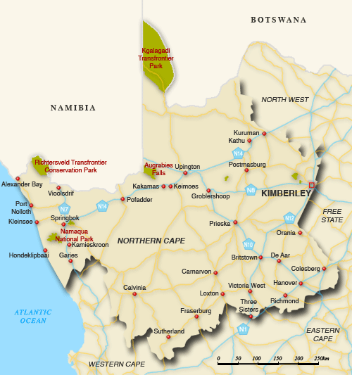
For my map, I will be using a map of the Northern Cape in South Africa as you can see here. Use a Map Chart of the Northern Cape.

Image


Colour the map a darkish red, From Alexander Bay to the borders of the Western Cape and the Atlantic Ocean. Kuruman to the city of Colesberg, which the two cities border the North West and the Free State. Include the Kgalagadi Transfrontier Park between Namibia and Botswana as well.

Like a connect-the-dots thing, start from Calvinia, a city near the Western Cape to Carnarvon, Britstown, De Aar, and finally Colesburg. Don’t include the cities: Sutherland, Fraserburg, Loxton, Victoria West, Hanover, Richmond and the Three Sisters. Don’t include Kimberley too.
Last edited by Saunders Global Security on Tue Jun 26, 2018 10:59 pm, edited 1 time in total.
.
.
.
SGNN: Jeff Bezos, age 65, declared dead in the hospital after deadly accident.|Saunders Global Economics and Resources Organization announces they will dig out every single diamond in diamond mines all over the world.
Yep the mental breakdown has already happened
Las Palmeras wrote:Somehow you can pull off a whimsical and capable teenage-ish leader all at once.
Garoarsholmur wrote:I really appreciate how hate-able your leader is. Not many people do that.

User avatar
Saunders Global Security
Political Columnist
 
Posts: 5
Founded: Jun 22, 2018
Ex-Nation

Postby Saunders Global Security » Thu Jun 28, 2018 9:49 am

Saunders Global Security wrote:Map request from Saunders Global Security.

For my map, I will be using a map of the Northern Cape in South Africa as you can see here. Use a Map Chart of the Northern Cape.


Colour the map a darkish red, From Alexander Bay to the borders of the Western Cape and the Atlantic Ocean. Kuruman to the city of Colesberg, which the two cities border the North West and the Free State. Include the Kgalagadi Transfrontier Park between Namibia and Botswana as well.

Like a connect-the-dots thing, start from Calvinia, a city near the Western Cape to Carnarvon, Britstown, De Aar, and finally Colesburg. Don’t include the cities: Sutherland, Fraserburg, Loxton, Victoria West, Hanover, Richmond and the Three Sisters. Don’t include Kimberley too.

/bump
.
.
.
SGNN: Jeff Bezos, age 65, declared dead in the hospital after deadly accident.|Saunders Global Economics and Resources Organization announces they will dig out every single diamond in diamond mines all over the world.
Yep the mental breakdown has already happened
Las Palmeras wrote:Somehow you can pull off a whimsical and capable teenage-ish leader all at once.
Garoarsholmur wrote:I really appreciate how hate-able your leader is. Not many people do that.

User avatar
Kyrusia
Retired Moderator
 
Posts: 10152
Founded: Nov 12, 2007
Capitalizt

Postby Kyrusia » Thu Jun 28, 2018 3:56 pm

Saunders Global Security wrote:
Saunders Global Security wrote:Map request from Saunders Global Security.

For my map, I will be using a map of the Northern Cape in South Africa as you can see here. Use a Map Chart of the Northern Cape.


Colour the map a darkish red, From Alexander Bay to the borders of the Western Cape and the Atlantic Ocean. Kuruman to the city of Colesberg, which the two cities border the North West and the Free State. Include the Kgalagadi Transfrontier Park between Namibia and Botswana as well.

Like a connect-the-dots thing, start from Calvinia, a city near the Western Cape to Carnarvon, Britstown, De Aar, and finally Colesburg. Don’t include the cities: Sutherland, Fraserburg, Loxton, Victoria West, Hanover, Richmond and the Three Sisters. Don’t include Kimberley too.

/bump

Just for the record, you need to wait 24-hours or when the thread falls off the first page, whichever is longer, otherwise it constitutes bump-spamming. There's also, simply put, no guarantee someone will decide to design you a map; sometimes simply no one is interested.
[KYRU]
old. roleplayer. the goat your parents warned you about.

User avatar
Thermodolia
Post Kaiser
 
Posts: 78484
Founded: Oct 07, 2011
Civil Rights Lovefest

Postby Thermodolia » Fri Jul 20, 2018 7:52 pm

Hey there y’all. So I got a request for a political map.

I’d like for it to look like this rough draft map here: https://imgur.com/a/Bw9kRRj

And I’d like the colors to be pastel colors. Thanks in advance. Also if you think of anything else tell me
Last edited by Thermodolia on Wed Jul 25, 2018 11:42 am, edited 1 time in total.
Male, Jewish, lives somewhere in AZ, Disabled US Military Veteran, Oorah!, I'm GAY!
I'm agent #69 in the Gaystapo!
>The Sons of Adam: I'd crown myself monarch... cuz why not?
>>Dumb Ideologies: Why not turn yourself into a penguin and build an igloo at the centre of the Earth?
Click for Da Funies

RIP Dya

User avatar
Janissero
Lobbyist
 
Posts: 16
Founded: Jul 20, 2018
Ex-Nation

Postby Janissero » Mon Jul 23, 2018 7:08 pm

Can I get this map in a light (but not flamboyantly light) green and can the borders be outlined in black. If you could make the background transparent that would be awesome! I am going to use it as my national map which will be a part of a bigger map for the region. The linked map is my Province map.

Thank you in advance!
Last edited by Janissero on Mon Jul 23, 2018 7:31 pm, edited 1 time in total.


"Don't Make Me Get My Main..."

User avatar
Almonaster Nuevo
Negotiator
 
Posts: 6827
Founded: Mar 11, 2007
Civil Rights Lovefest

Postby Almonaster Nuevo » Tue Jul 24, 2018 3:09 am

Janissero wrote:Can I get this map in a light (but not flamboyantly light) green and can the borders be outlined in black. If you could make the background transparent that would be awesome! I am going to use it as my national map which will be a part of a bigger map for the region. The linked map is my Province map.

Thank you in advance!


Just this...?
Image
Christian Democrats wrote:Would you mind explaining what's funny? I'm not seeing any humor.
The Blaatschapen wrote:I'll still graze the forums with my presence
Please do not TG me about graphics requests. That's what the threads are there for.

User avatar
Janissero
Lobbyist
 
Posts: 16
Founded: Jul 20, 2018
Ex-Nation

Postby Janissero » Tue Jul 24, 2018 5:27 pm

Almonaster Nuevo wrote:
Janissero wrote:Can I get this map in a light (but not flamboyantly light) green and can the borders be outlined in black. If you could make the background transparent that would be awesome! I am going to use it as my national map which will be a part of a bigger map for the region. The linked map is my Province map.

Thank you in advance!


Just this...?
Image


That'll do :)


"Don't Make Me Get My Main..."

User avatar
Dahon
Negotiator
 
Posts: 5892
Founded: Nov 11, 2015
Ex-Nation

Postby Dahon » Wed Jul 25, 2018 6:34 am

Hello. For now I'd like to request a map of my nation based on this map:

Image

Now, how you do that will be up to you. However, I do request that these be heeded:

1. That the "mouth" of the main island be reoriented due southwest;
2. That the islands to the north be eliminated entirely;
3. That the superimposed inset map to the lower right corner of the image be removed, to be replaced by the contours of the main island, the drawing of which I leave to your discretion so long as it does not directly affect the boomerang image;
4. That the southwest of the "mouth" be studded with 117 small islands, all of them an appreciable distance away from the main island; and
5. That the western part of the main island be so enlarged and lengthened that it would be of nearly of the same length and width as the eastern part, even as it retains its boomerang shape.

If you want further clarifications on this matter, please TG me.
Authoritarianism kills all. Never forget that.

-5.5/-7.44

al-Ibramiyah (inactive; under research)
Moscareinas (inactive)
Trumpisslavia (inactive)
Dahon the Alternative (inactive; under research)
Our Heavenly Dwarf (Forum 7)

User avatar
Thermodolia
Post Kaiser
 
Posts: 78484
Founded: Oct 07, 2011
Civil Rights Lovefest

Postby Thermodolia » Wed Jul 25, 2018 11:42 am

Thermodolia wrote:Hey there y’all. So I got a request for a political map.

I’d like for it to look like this rough draft map here: https://imgur.com/a/Bw9kRRj

And I’d like the colors to be pastel colors. Thanks in advance. Also if you think of anything else tell me

Just posting this for all to see again
Male, Jewish, lives somewhere in AZ, Disabled US Military Veteran, Oorah!, I'm GAY!
I'm agent #69 in the Gaystapo!
>The Sons of Adam: I'd crown myself monarch... cuz why not?
>>Dumb Ideologies: Why not turn yourself into a penguin and build an igloo at the centre of the Earth?
Click for Da Funies

RIP Dya

User avatar
Almonaster Nuevo
Negotiator
 
Posts: 6827
Founded: Mar 11, 2007
Civil Rights Lovefest

Postby Almonaster Nuevo » Wed Jul 25, 2018 2:30 pm

Dahon wrote:Hello. For now I'd like to request a map of my nation based on this map:

(Image)

Now, how you do that will be up to you. However, I do request that these be heeded:

1. That the "mouth" of the main island be reoriented due southwest;
2. That the islands to the north be eliminated entirely;
3. That the superimposed inset map to the lower right corner of the image be removed, to be replaced by the contours of the main island, the drawing of which I leave to your discretion so long as it does not directly affect the boomerang image;
4. That the southwest of the "mouth" be studded with 117 small islands, all of them an appreciable distance away from the main island; and
5. That the western part of the main island be so enlarged and lengthened that it would be of nearly of the same length and width as the eastern part, even as it retains its boomerang shape.

If you want further clarifications on this matter, please TG me.


I moved the inset to the top left instead. If you particularly want it lower right then that's an easy fix.
Image
Christian Democrats wrote:Would you mind explaining what's funny? I'm not seeing any humor.
The Blaatschapen wrote:I'll still graze the forums with my presence
Please do not TG me about graphics requests. That's what the threads are there for.

User avatar
Dahon
Negotiator
 
Posts: 5892
Founded: Nov 11, 2015
Ex-Nation

Postby Dahon » Wed Jul 25, 2018 5:34 pm

That's much better. However, a few things I'd like to see corrected (if "corrected" is the word), the majority of them having to do with further deletions, as follows:

1. The inset MUST be removed, not repositioned.
2. The western section of the main island should be made wider.
3. Remove the big island off the tip of the southwestern part of the main island.
4. Remove the bit of river at the east-central portion of the main island.
Authoritarianism kills all. Never forget that.

-5.5/-7.44

al-Ibramiyah (inactive; under research)
Moscareinas (inactive)
Trumpisslavia (inactive)
Dahon the Alternative (inactive; under research)
Our Heavenly Dwarf (Forum 7)

User avatar
Almonaster Nuevo
Negotiator
 
Posts: 6827
Founded: Mar 11, 2007
Civil Rights Lovefest

Postby Almonaster Nuevo » Wed Jul 25, 2018 6:25 pm

Dahon wrote:That's much better. However, a few things I'd like to see corrected (if "corrected" is the word), the majority of them having to do with further deletions, as follows:

1. The inset MUST be removed, not repositioned.
2. The western section of the main island should be made wider.
3. Remove the big island off the tip of the southwestern part of the main island.
4. Remove the bit of river at the east-central portion of the main island.


Image
Christian Democrats wrote:Would you mind explaining what's funny? I'm not seeing any humor.
The Blaatschapen wrote:I'll still graze the forums with my presence
Please do not TG me about graphics requests. That's what the threads are there for.

User avatar
Dahon
Negotiator
 
Posts: 5892
Founded: Nov 11, 2015
Ex-Nation

Postby Dahon » Wed Jul 25, 2018 6:27 pm

That's perfect. Thank you for your help.
Last edited by Dahon on Wed Jul 25, 2018 6:28 pm, edited 1 time in total.
Authoritarianism kills all. Never forget that.

-5.5/-7.44

al-Ibramiyah (inactive; under research)
Moscareinas (inactive)
Trumpisslavia (inactive)
Dahon the Alternative (inactive; under research)
Our Heavenly Dwarf (Forum 7)

User avatar
Lancastria
Lobbyist
 
Posts: 22
Founded: Jun 30, 2018
Ex-Nation

THIRD REPOST (Please kill me...) JK

Postby Lancastria » Sun Jul 29, 2018 4:46 am

Hello, i was wondering if anyone could help me by creating a map for my P2TM RP nation described here.
https://forum.nationstates.net/viewtopic.php?f=31&t=447000&start=25 - the claims are somewhat vague, but what i would like is a map that shows my claims of Tanzania, Mozambique, Kenya, Madagascar, The Maldives, and any major port-cities in Western Sumatra and other territories listed there.
I'd also like to know what you think about this fictional nation's history, it has yet to be edited and fixed grammarly, yet i feel as if it came of fantastic, for my decent RPing skills.

Send me a message, either via telegram to the Barbary States or PM me on Discord at: PILLOWWILLOW#4824

User avatar
Almonaster Nuevo
Negotiator
 
Posts: 6827
Founded: Mar 11, 2007
Civil Rights Lovefest

Postby Almonaster Nuevo » Sun Jul 29, 2018 5:50 am

Lancastria wrote:Hello, i was wondering if anyone could help me by creating a map for my P2TM RP nation described here.
https://forum.nationstates.net/viewtopic.php?f=31&t=447000&start=25 - the claims are somewhat vague, but what i would like is a map that shows my claims of Tanzania, Mozambique, Kenya, Madagascar, The Maldives, and any major port-cities in Western Sumatra and other territories listed there.
I'd also like to know what you think about this fictional nation's history, it has yet to be edited and fixed grammarly, yet i feel as if it came of fantastic, for my decent RPing skills.

Send me a message, either via telegram to the Barbary States or PM me on Discord at: PILLOWWILLOW#4824


Image
Last edited by Almonaster Nuevo on Sun Jul 29, 2018 5:55 am, edited 1 time in total.
Christian Democrats wrote:Would you mind explaining what's funny? I'm not seeing any humor.
The Blaatschapen wrote:I'll still graze the forums with my presence
Please do not TG me about graphics requests. That's what the threads are there for.

User avatar
Lancastria
Lobbyist
 
Posts: 22
Founded: Jun 30, 2018
Ex-Nation

Postby Lancastria » Sun Jul 29, 2018 6:11 am

Almonaster Nuevo wrote:
Lancastria wrote:Hello, i was wondering if anyone could help me by creating a map for my P2TM RP nation described here.
https://forum.nationstates.net/viewtopic.php?f=31&t=447000&start=25 - the claims are somewhat vague, but what i would like is a map that shows my claims of Tanzania, Mozambique, Kenya, Madagascar, The Maldives, and any major port-cities in Western Sumatra and other territories listed there.
I'd also like to know what you think about this fictional nation's history, it has yet to be edited and fixed grammarly, yet i feel as if it came of fantastic, for my decent RPing skills.

Send me a message, either via telegram to the Barbary States or PM me on Discord at: PILLOWWILLOW#4824


Image

Many thanks.

PreviousNext

Advertisement

Remove ads

Return to Factbooks and National Information

Who is online

Users browsing this forum: Shearoa

Advertisement

Remove ads