Page 1 of 1

Your Nation's States/Reigons

PostPosted: Thu May 08, 2014 4:52 am
by Caterasia
Many countries are classified into states or regions.
Considering your country is divided this way, post them below for reference of all! Maybe include a little tid-bit or what not!

Your Nation's States/Reigons

PostPosted: Thu May 08, 2014 5:09 am
by Caterasia
Caterasia is divided into 5 Reigons.
Northeast-North-Middle-South-Northwest
All reigons are environmentally stunning. BUT! They all have their differences.
Caterasia has 37 states. 5 of those 37 are islands. There are other islands besides those in Caterasia, but they are not included in the count!
Northeast
Equicate {Capital State; includes capital city of Aphri}
Marguerite {head of currency production; thus the Marguerite}
St.Poniez {#1 Shetland Pony Breeder in all of NationStates}
Bridle Point
Horsetopia
New Kentucky {Famous for breeding beautiful Thoroughbreds}
Marallion
North
New Snaffle {Like old snaffle, but new}
Coltskaro
Sidra
Canterlot
Cloudsdale
Zaroka
Bates
Middle
Io
Sapphire City
Rain Song
Mistelta
Strax
Athena
Candor
Suni
Razzle
Rosie Island
South
Manehattan
Ponyville {Leader in production of peaches, oranges and apples in the nation}
North Pommell
South Pommell
Pinkie Pye
Ravenclaw
Rassilon Island
Dauntless Island
Amelia Island
Hope Island
West
Harcourt
Lyra
Equestria
Gallifrey
Amity
.
.
.
.
Caterasia is an environmentally stunning nation and none of these state's are any exception!

PostPosted: Thu May 08, 2014 5:30 am
by Fatherland Germany
The German Empire is divide into 14 regions

Berlin
Brandenburg
East Prussia
Hanover
Hesse-Nassau
Hohenzollern
Pomerania
Posen
Rhine Province
Saxony
Schleswig-Holstein
Silesia
West Prussia
Westphalia

PostPosted: Thu May 08, 2014 5:43 am
by Hladgos
Hladgos is divided into thirteen states according the the maps that came with Hladgos when it spontaneously appeared. There has only been one amendment to state boundries.

PostPosted: Thu May 08, 2014 5:46 am
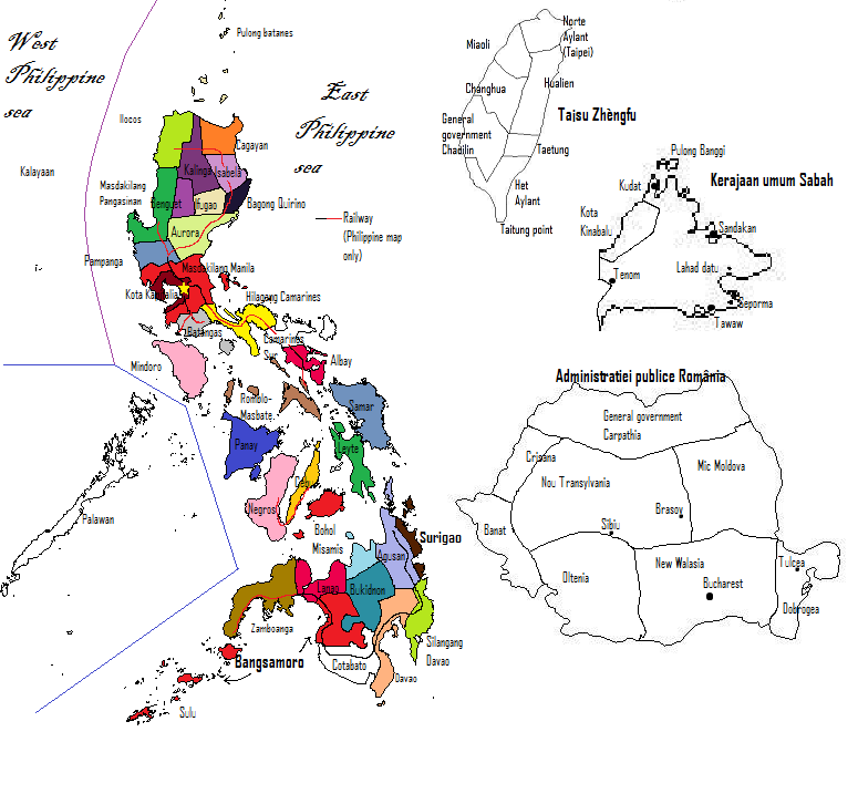
by Calabarzon
Province - Capital

CAvite - Imus
LAguna - Santa Crus
BAtangas - Taal City
Rizal - Rizal City
queZON - Lucena City

Our demonym, also.

PostPosted: Thu May 08, 2014 5:47 am
by The New American commonwealth
States of the New American Commonwealth
New York
Pennsylvania
New Jersey
Massachusetts
Connecticut
Rhode Island
Maine
New Hampshire
Vermont
Virginia
South Carolina
North Carolina
Georgia
Ohio
Kentucky
Tennessee
Louisiana
Missouri
Alabama
Mississippi
Indiana
Illinois

PostPosted: Thu May 08, 2014 6:01 am
by DunNa nGall
Image

These are the electoral and administrative divisions of the country. These have very little autonomy.

PostPosted: Fri May 09, 2014 5:51 am
by Caterasia
Bump

PostPosted: Fri May 09, 2014 6:13 am
by Breheim
Breheim is divided into 5 Storfylker, or Regions, which is divided into 26 fylker. Map of the Storfylker and map of the Fylker.

Taranger
Climate: Boreal
Capital: Storvik
Stereotypes: Patriotic, puritan, arrogant, irreligious.
Fylker: Storvik, Justland, Nordtaranger, Sørtaranger, Langkyst, Dobbelfjord.

Vestøy
Climate: Boreal
Capital: Bjørnborg
Stereotypes: Religious, conservative, mumbling.
Fylker: Bjørnborg, Kirkby, Kristifjord, Østfjord, Vestfjord, Bakka, Ristus.

Alfheim
Climate: Temperate
Capital: Alfby
Stereotypes: Proud, greedy, victim complex.
Fylker: Alfby, Ergvik, Rosta, Alfheim.

Nordbreheim
Climate: Boreal/Arctic
Capital: Odinberg
Stereotypes: Alcoholic, manly, egalitarian, uneducated.
Fylker: Svartskog, Jørland, Snøland, Runitland, Norraøya, Nordland, Gronderkyst.

Fjordland
Climate: Oceanic.
Capital: Dramre
Stereotypes: Angry, drunk, sailors, stoic.
Fylker: Fjordland, Torshavn.

PostPosted: Sat May 10, 2014 2:28 pm
by Davinhia
Davinhia county
biggest

forest county
has deep forests

western state
owns desert area

and

farmeria
owns the farm areas

PostPosted: Sat May 10, 2014 2:31 pm
by Vulkanas
Image

PostPosted: Sat May 10, 2014 2:35 pm
by Anollasia
Our provinces are Baskent, Guney, Dogu, Bati, and Kuzey.

PostPosted: Sun May 11, 2014 2:10 am
by Hyfling
Hyfling is divided into 5 major regions:

-North
-West
-Central-Below-North
-Central Hyfling
-Coastal Hyfling

PostPosted: Sun May 11, 2014 2:20 am
by The Austria-Hungary
Capital= Vienna
States

German Austria
Hungary
German Bohemia
Bohemia
German Moravia
Trentino
Trieste
Carniola
Croatia
Bosnia
Vojvodina
Transylvania
Szekler Land
East Galica
west Galica
Slovakia

PostPosted: Sun May 11, 2014 2:28 am
by Valkalan
The mainland of the Empire of Valkalan is divided into 4 main regions:
Valkalan, the empire's core and namesake. Valkalan is the heart of Valk culture, finance and industry.
Vanadia, the northernmost region of the Empire and the original homeland of the Valk people.
Drajal, a desert region to the south of Valkalan that contains some the Empire's most valuable ports. It is also the core of the Empire's entertainment industry.
Ulekar, the eastern frontier of the Empire sometimes known as the "Alk Ojst" (Old East). The region's conquest and settlement over the last few centuries has become a cherished part of history.

PostPosted: Sun May 11, 2014 2:28 am
by Jaritas
There are three regions includind the Capital's Territory:

Navio Region
Tatak Region
Ruzza Region
Capital Territory of Mliktown

PostPosted: Sun May 11, 2014 2:39 am
by Wraland
Wraland is divided into 10 Zones.
Image
We border New Austzeland to the west and Guerro to the east.

PostPosted: Mon May 12, 2014 5:41 am
by Suvarnadvipa
There are 9 states in the Federal Republic of Suvarnadvipa. Two of them have been given the status as autonomous states.

Image

The legend of the map above is as follows:
1 - Palembang State (capital state)
2 - Aceh State (autonomous state)
3 - Batak State (autonomous state)
4 - Riau State
5 - Padang State
6 - Jambi State
7 - Bengkulu State
8 - Belitung State
9 - Lampung State

PostPosted: Mon May 12, 2014 5:55 am
by The Kingdom of Newcastle
Newcastle is divided into four regions, each of which are centered around a major city,

Georgetown
This part of Newcastle is the largest and most populous island in the Newcastle archipelago and is also named after the capital of Newcastle, Georgetown. Newcastle is famous for it's many mountains and fords and contains three fords: Songford, Greenford, Eastford, and Westford. Greenford, which is the largest of the four fjords of Newcastle is world renown for it's beautiful scenery and it's tranquil setting.
Wellington
This is the second largest part of Newcastle, Wellington, which also has a mountainous terrain is world famous for Mt. Newcastle, one of the tallest and most visible mountains in Newcastle. Although Wellington is named after the city of Wellington, the second-largest city in Newcastle, it is also famous for it's numerous biking trails.
Northford
Northford is a small, hilly island with green valleys that's famous for it's green, open pastures. The capital of Northford is Stratford, which is the third largest city in Newcastle, after Georgetown and Wellginton.
Southford
Southford is the third largest island i the Newcastle archipelago and is famous for it's stunning green valleys and it's massive, scenic mountains. Southfrod is uninhabited, however, you can take daily ferry to there from Georgetown.

PostPosted: Mon May 12, 2014 6:01 am
by Soled
I have a factbook on it (the image is too large for the forums)

PostPosted: Mon May 12, 2014 6:11 am
by Asigna
Image

Bayan kotas in the politically annexed territories (not included: Bayan kota administrative of Northern Australia which acts as a single political entity)

PostPosted: Mon May 12, 2014 7:15 am
by Lalaki
The nation is a small community, akin to a city-state. However, when the citizens are discussing public policy, the community is divided into two sections to make administration easier. The town center, and the outer area. Other than to denote location on a bill (ex: "1,000 coins shall be granted to fund construction projects in the town center") there is no real difference between the two regions.

PostPosted: Mon May 12, 2014 8:14 am
by Alizeria
Alizeria is divided into 19 counties, which form the top-tier of local government (with local authorities forming the second tier).
Image


Most of these counties are based on historical divisions which have remained unaltered for centuries and historically counties were ruled by Earls (formerly known as 'Counts') or sometimes by Marquesses. Some counties, most notably Palatine, Albion and Chiridia were once principalities, or small Kingdoms in their own right prior to 810AD. However, the vast majority of counties were formed following the unification of Alizeria as a single Kingdom and some, such as Palatine, have been subdivided over the centuries.

The current geographical borders of the Counties have remained unchanged since 1699, although in the 1980s three 'Metro Counties' were carved out of existing counties due to large concentrations of urban populations within them. The three 'Metro Counties' are Greater Krostuk, Greater Auckonto and Greater Norskeberg.

County Centerbury continues to exist only for the sake of tradition, with the Centerton City Council doing most of the de facto administration of the county. Likewise for County Kingsbay, where Everton City has expanded to encompass 80% of the county.

The County Councils continue to wield a considerable influence in matters of local government, with the administration of local police forces and local health boards entrusted to them, despite the police and healthcare system being funded by general taxation.

Unlike Local Authorities, which receive funding through rates and property taxes, Counties do not directly receive revenue from their citizens and as such the central government of Alizeria tends to allocate funds to the counties in proportion to their population. Again, this is usually most notable in terms of the way that police forces and local health boards are funded.

CountyCounty townPopulation
Greater KrostukKrostuk City3,597,000
AucklandRegina34,000
ChiridiaWatev514,000
Greater AuckontoAuckonto1, 102,000
KingsbayEverton939,000
LiverseaWoolworth40,000
AvonheadAvondale128,000
IanshireMasonville104,000
WichburyPlainbury330,000
CenterburyCenterton678,000
PalatineKrystel614,000
WilliamshireFeadwich600,000
WellingtonWellington Town214,000
BelsloughPaddytown340,000
WestfieldHenderson162,000
ChristchurchCanobrie550,000
Greater NorskebergNorskeberg1,416,000
AlbionKjork410,000
OtagoSouthe304,000

PostPosted: Mon May 12, 2014 8:43 am
by Hircus
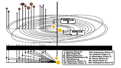
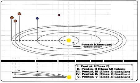
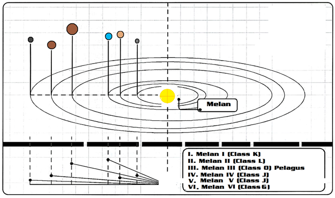
Systems
Hircus-- Dual Star System. Stars are Class K (Orange)
Image

Pentak---Single Class G2V (Yellow dwarf)
Image

Melan-- Single Type: G5 II (Yellow Giant)
Image

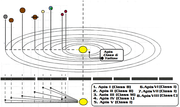
Apis --Class G4 II (Yellow) Star
Image

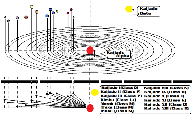
Kaijado--Dual Star--Class M4 IV Red Giant, Class G2 V Yellow Dwarf
Image

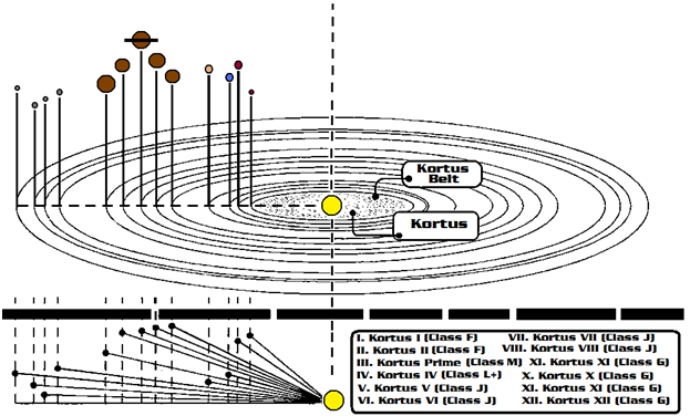
Kortus--G5 III (Yellow) Star--
Image

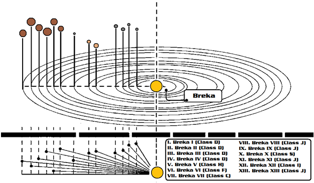
Breka System --Class G4 II (Yellow) Star
Image

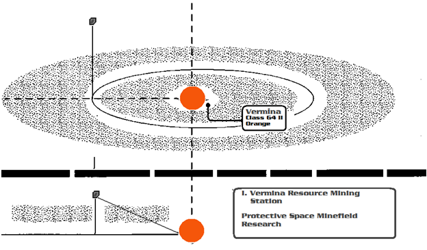
Vermina-- Class G4 II Star
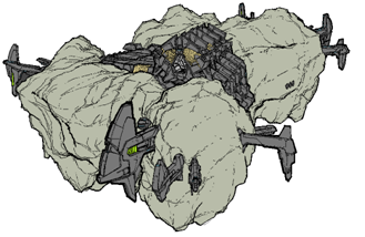
Vermina is an asteroid debris field orbiting a star.
Image

Image

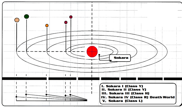
Sokara --Type M5 IV Super Red Giant
Image

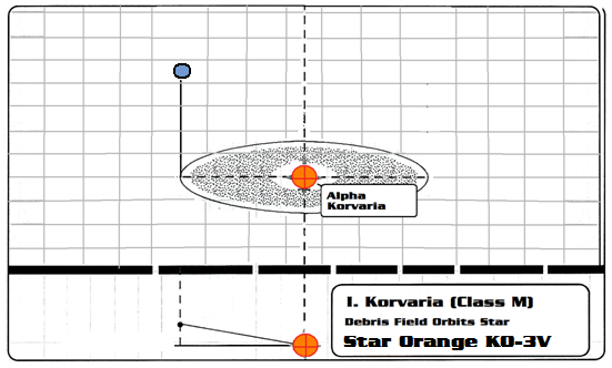
Korvaria--Class KO-3V Orange
We have an established colony and share the planet with several other Stellar civilizations.
Image