
Advertisement

![]() by The High Lords » Mon Feb 23, 2015 6:43 pm
by The High Lords » Mon Feb 23, 2015 6:43 pm
Insaeldor wrote:So as far as the map goes... Maybe we could expand and add a new continent? Just an idea.
![]() by Globus » Mon Feb 23, 2015 6:47 pm
by Globus » Mon Feb 23, 2015 6:47 pm

![]() by Insaeldor » Mon Feb 23, 2015 6:48 pm
by Insaeldor » Mon Feb 23, 2015 6:48 pm
The High Lords wrote:Insaeldor wrote:So as far as the map goes... Maybe we could expand and add a new continent? Just an idea.
That's in the discussion... I'm just not sure what it'll be like. How many bays, peninsulas, great lakes, etc... Big, little, etc. etc.
And what part of the map? Shall we extend it in some direction as to make room?
![]() by Glorious ReBublic of Alevstan » Mon Feb 23, 2015 8:48 pm
by Glorious ReBublic of Alevstan » Mon Feb 23, 2015 8:48 pm
Insaeldor wrote:The High Lords wrote:
That's in the discussion... I'm just not sure what it'll be like. How many bays, peninsulas, great lakes, etc... Big, little, etc. etc.
And what part of the map? Shall we extend it in some direction as to make room?
Maybe a general expansion with some smaller new continents in the north, south, east and west.
I personally however feel that the north is lacking in land so maybe a new northern continent. Lots of fjords, maybe a big inlet and a slightly more boggy Lakeland in the southeast.
![]() by The United Regions » Mon Feb 23, 2015 9:38 pm
by The United Regions » Mon Feb 23, 2015 9:38 pm
![]() by Republic of Vietnam » Mon Feb 23, 2015 9:42 pm
by Republic of Vietnam » Mon Feb 23, 2015 9:42 pm

![]() by Glorious ReBublic of Alevstan » Mon Feb 23, 2015 10:31 pm
by Glorious ReBublic of Alevstan » Mon Feb 23, 2015 10:31 pm
Republic of Vietnam wrote:Wait...
If we are allowed to have out own land, not drawn out...
*Gasps*
DIPS on irl Vietnam
So for my section, basically irl Indochina for the borders looks but I only want Vietnam. Would that be okay?
![]() by Republic of Vietnam » Mon Feb 23, 2015 10:56 pm
by Republic of Vietnam » Mon Feb 23, 2015 10:56 pm
Glorious Rebublic of Alevstan wrote:Republic of Vietnam wrote:Wait...
If we are allowed to have out own land, not drawn out...
*Gasps*
DIPS on irl Vietnam
So for my section, basically irl Indochina for the borders looks but I only want Vietnam. Would that be okay?
I think we would draw out borders, not landmass. idk though, still being decided
![]() by Bratislav » Tue Feb 24, 2015 12:40 am
by Bratislav » Tue Feb 24, 2015 12:40 am
Globus wrote:Allowing nations to draw their borders seems like it would be a mess. There's 80 nations, at least 40 active. How would we ever coordinate the drawing of such borders?
![]() by Bratislav » Tue Feb 24, 2015 12:42 am
by Bratislav » Tue Feb 24, 2015 12:42 am

![]() by Viridisolum » Tue Feb 24, 2015 12:46 am
by Viridisolum » Tue Feb 24, 2015 12:46 am
Bratislav wrote:Globus wrote:Allowing nations to draw their borders seems like it would be a mess. There's 80 nations, at least 40 active. How would we ever coordinate the drawing of such borders?
It would be a mess, I don't think this is a good idea. Just imagine every new nation has to 'draw' their country on the map. It will be a big headache, we should stick to the numbered-plot system for now.

![]() by Bratislav » Tue Feb 24, 2015 12:48 am
by Bratislav » Tue Feb 24, 2015 12:48 am
![]() by The New Lowlands » Tue Feb 24, 2015 12:58 am
by The New Lowlands » Tue Feb 24, 2015 12:58 am
Bratislav wrote:Globus wrote:Allowing nations to draw their borders seems like it would be a mess. There's 80 nations, at least 40 active. How would we ever coordinate the drawing of such borders?
It would be a mess, I don't think this is a good idea. Just imagine every new nation has to 'draw' their country on the map. It will be a big headache, we should stick to the numbered-plot system for now.
![]() by Bratislav » Tue Feb 24, 2015 1:08 am
by Bratislav » Tue Feb 24, 2015 1:08 am
The New Lowlands wrote:Bratislav wrote:
It would be a mess, I don't think this is a good idea. Just imagine every new nation has to 'draw' their country on the map. It will be a big headache, we should stick to the numbered-plot system for now.
There's no need for an either-or decision here.
One big problem with the plot system is that it fails to accurately represent realistic sizes for certain nations: it's a given, for example, that countries formed by settlement colonialism will typically have much larger sizes than their colonising powers, whether they come from a single continent or more than one, or that more populous old-world countries will typically be of larger size than their less-populous cousins: India is bigger than Britain, Indonesia is bigger than France et cetera.
There also seems to be very little rhyme or reason with regards to cultures or linguistic groups being distributed across the continents, with Vietnam (an Austro-Asiatic culture) being next to Sveltlana (presumably some variation on Germanic.) There's a similar effect on climate.
Having a mapmaker or a team of mapmakers working together to process applications (which will include things like population size and population density – best not to include size, in my experience as Hemithea's mapmaker, because people will put down arbitrary or absurd figures, and population density might actually make them think about what their country's climate is like) will let them judge appropriately where to place nations according to the culture, climate, population size, and maybe economic factors they have: and we'll just leave the deciding the shape to them.
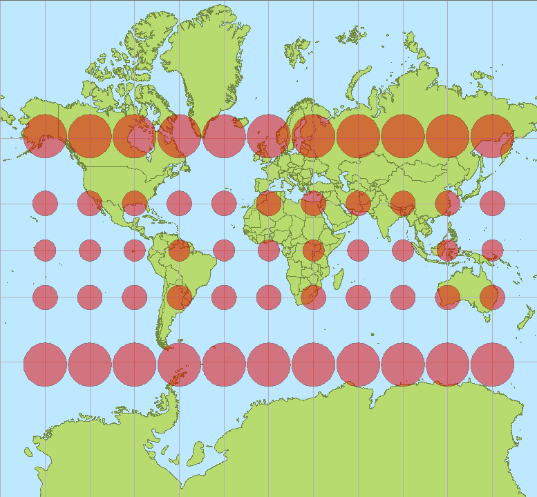
Of course, to do all this we're going to need an accurate scale for the map; we can either determine that 1px is equal to a given amount of square kilometres, or we can account for map projection (all the circles on that map are the same area adjusting for projection) although personally I'd recommend just not bothering with the latter.
![]() by Viridisolum » Tue Feb 24, 2015 1:09 am
by Viridisolum » Tue Feb 24, 2015 1:09 am
The New Lowlands wrote:Bratislav wrote:
It would be a mess, I don't think this is a good idea. Just imagine every new nation has to 'draw' their country on the map. It will be a big headache, we should stick to the numbered-plot system for now.
There's no need for an either-or decision here.
One big problem with the plot system is that it fails to accurately represent realistic sizes for certain nations: it's a given, for example, that countries formed by settlement colonialism will typically have much larger sizes than their colonising powers, whether they come from a single continent or more than one, or that more populous old-world countries will typically be of larger size than their less-populous cousins: India is bigger than Britain, Indonesia is bigger than France et cetera.
There also seems to be very little rhyme or reason with regards to cultures or linguistic groups being distributed across the continents, with Vietnam (an Austro-Asiatic culture) being next to Sveltlana (presumably some variation on Germanic.) There's a similar effect on climate.
Having a mapmaker or a team of mapmakers working together to process applications (which will include things like population size and population density – best not to include size, in my experience as Hemithea's mapmaker, because people will put down arbitrary or absurd figures, and population density might actually make them think about what their country's climate is like) will let them judge appropriately where to place nations according to the culture, climate, population size, and maybe economic factors they have: and we'll just leave the deciding the shape to them.
Of course, to do all this we're going to need an accurate scale for the map; we can either determine that 1px is equal to a given amount of square kilometres, or we can account for map projection (all the circles on that map are the same area adjusting for projection) although personally I'd recommend just not bothering with the latter.
![]() by The New Lowlands » Tue Feb 24, 2015 1:41 am
by The New Lowlands » Tue Feb 24, 2015 1:41 am
Bratislav wrote:The New Lowlands wrote:There's no need for an either-or decision here.
One big problem with the plot system is that it fails to accurately represent realistic sizes for certain nations: it's a given, for example, that countries formed by settlement colonialism will typically have much larger sizes than their colonising powers, whether they come from a single continent or more than one, or that more populous old-world countries will typically be of larger size than their less-populous cousins: India is bigger than Britain, Indonesia is bigger than France et cetera.
There also seems to be very little rhyme or reason with regards to cultures or linguistic groups being distributed across the continents, with Vietnam (an Austro-Asiatic culture) being next to Sveltlana (presumably some variation on Germanic.) There's a similar effect on climate.
Having a mapmaker or a team of mapmakers working together to process applications (which will include things like population size and population density – best not to include size, in my experience as Hemithea's mapmaker, because people will put down arbitrary or absurd figures, and population density might actually make them think about what their country's climate is like) will let them judge appropriately where to place nations according to the culture, climate, population size, and maybe economic factors they have: and we'll just leave the deciding the shape to them.
Of course, to do all this we're going to need an accurate scale for the map; we can either determine that 1px is equal to a given amount of square kilometres, or we can account for map projection (all the circles on that map are the same area adjusting for projection) although personally I'd recommend just not bothering with the latter.
re-organizng all of Atlas based on culture and history is near-impossible, given we have new members always coming and the fact that most borders cannot be changed given already established regional histories and RPs that have taken place. I'm not sure if this 'group of mapmapkers' will be able to process each an every application and diligently update the map. We don't even have the current map up-to-date, how is it expected that it will thus be updated upon each and every applicant?
![]() by Valaran » Tue Feb 24, 2015 2:34 am
by Valaran » Tue Feb 24, 2015 2:34 am
![]() by The High Lords » Tue Feb 24, 2015 4:11 am
by The High Lords » Tue Feb 24, 2015 4:11 am
Valaran wrote:Yeah, by and large, we shouldn't redraw existing borders - it would be an utter nightmare. My suggestion in the TG was to not use the plot system from here on out for a new continent.
That is just my view, so feel free to disagree. But still.
![]() by Valaran » Tue Feb 24, 2015 5:00 am
by Valaran » Tue Feb 24, 2015 5:00 am
The High Lords wrote:Valaran wrote:Yeah, by and large, we shouldn't redraw existing borders - it would be an utter nightmare. My suggestion in the TG was to not use the plot system from here on out for a new continent.
That is just my view, so feel free to disagree. But still.
Current borders can remain the same, but if the member states involved - i.e. me and roski - want to switch something around, then that's fine, to an extent. Also, RP gains and losses are fine as well.
New continent borders.will be freely drawn, and I'm sure i can help ceneria with this. It's not as big of a deal as you may think it is - and if it is indeed a problem, then we'll revert. No biggie.

![]() by Lolomz » Tue Feb 24, 2015 5:56 am
by Lolomz » Tue Feb 24, 2015 5:56 am
![]() by Viridisolum » Tue Feb 24, 2015 6:15 am
by Viridisolum » Tue Feb 24, 2015 6:15 am
Lolomz wrote:I Could Be Respented By Other Nation From The Region?
![]() by Bratislav » Tue Feb 24, 2015 7:22 am
by Bratislav » Tue Feb 24, 2015 7:22 am
![]() by The High Lords » Tue Feb 24, 2015 8:53 am
by The High Lords » Tue Feb 24, 2015 8:53 am
Bratislav wrote:The thing is guys, yeah we can have a new continent for new incoming members, but it would be a nightmare in terms of RP history, if half of members of Currente continent decide to move to the new continent. It would kill all the mutual RP history and timeline that we have built up. So that needs to be avoided.
![]() by Roski » Tue Feb 24, 2015 8:57 am
by Roski » Tue Feb 24, 2015 8:57 am
Bratislav wrote:The thing is guys, yeah we can have a new continent for new incoming members, but it would be a nightmare in terms of RP history, if half of members of Currente continent decide to move to the new continent. It would kill all the mutual RP history and timeline that we have built up. So that needs to be avoided.
Return to Factbooks and National Information
Users browsing this forum: No registered users