Niggab wrote:Please tell me when you have time for me .
Niggab
NEVER.
actually yes, but its going to be a bit of a wait. I have Arcua/Olypmia and Trivval to do before I bother opening new requests.

Advertisement

![]() by The Krieg Empire » Sat Sep 25, 2010 3:48 pm
by The Krieg Empire » Sat Sep 25, 2010 3:48 pm
Niggab wrote:Please tell me when you have time for me .
Niggab
![]() by Trivval » Sat Sep 25, 2010 5:49 pm
by Trivval » Sat Sep 25, 2010 5:49 pm
Trivval wrote:
OKAY, Mate. I hope this isn't too much, but I'm goign to double your workload right now (Sorry)
Can you try and get this done for me by Wednesday in 2 weeks? If its too much, okay, but thats when I want to put up my nations website (Yus, I'ma pay for custom domain and all) and I don't want to bug the Server d00ds too much, so I want to limit my updates to once every two months, so therefore it would be appreicated if I could get it soon as then I don't have to wait two months to show off my awesomeness.

![]() by Power and Stability » Sat Sep 25, 2010 5:55 pm
by Power and Stability » Sat Sep 25, 2010 5:55 pm
![]() by The Krieg Empire » Sun Oct 03, 2010 11:59 am
by The Krieg Empire » Sun Oct 03, 2010 11:59 am
Lakhon wrote:My order has been canceled.
![]() by The Krieg Empire » Sun Oct 03, 2010 12:26 pm
by The Krieg Empire » Sun Oct 03, 2010 12:26 pm
![]() by Cyrupe » Wed Oct 06, 2010 7:40 am
by Cyrupe » Wed Oct 06, 2010 7:40 am
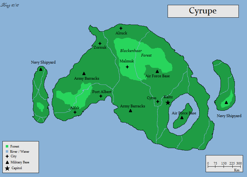
The Krieg Empire wrote:@Cyrupe: What do you want your random forests labeled as
![]() by The Krieg Empire » Wed Oct 06, 2010 7:56 am
by The Krieg Empire » Wed Oct 06, 2010 7:56 am
![]() by The Krieg Empire » Thu Oct 07, 2010 11:11 am
by The Krieg Empire » Thu Oct 07, 2010 11:11 am
Cyrupe wrote:Krieg, I must admit here. . . I love you now. That was well worth the wait. It's fine for me, nothing needs to be changed around. Thank you very much!
Trivval wrote:GAH. Cancel me aswell. Judea's under a massive overhaul.
![]() by Power and Stability » Thu Oct 07, 2010 2:19 pm
by Power and Stability » Thu Oct 07, 2010 2:19 pm
![]() by Jinavia » Wed Oct 20, 2010 2:26 pm
by Jinavia » Wed Oct 20, 2010 2:26 pm
![]() by Power and Stability » Wed Oct 20, 2010 6:42 pm
by Power and Stability » Wed Oct 20, 2010 6:42 pm
Jinavia wrote:Jinavia:
- Peninsula, large and medium in length, from east to west (mountain borders in the east, seas in the north, south and west)
- Eastern mountain border, from coast to coast (as is for Italy, but in the east instead of in the north)
- Central mountain backbone, from eastern moutain range to the western coast and two plains, in the south and in the north of peninsula
- Northern coast rich in fjords
- Western large gulf, rich in bays
- Four major islands (from north to south: Nikkeldepain, Porlumma, New Ithaca and Rodrom) in the western sea
- Numerous (4 or 5) nameless islands, external to the four main islands
- The Rauros, Jinavia's longest river, flows from the north-eastern range, crosses central backbone range and crosses the southern plain on its way to the southern Sea.
The country is situated at the outer rim of his continent plate, leading to considerable seismic and volcanic activity.
![]() by The Krieg Empire » Fri Oct 22, 2010 2:55 pm
by The Krieg Empire » Fri Oct 22, 2010 2:55 pm
![]() by Wewtlandem » Sun Oct 24, 2010 1:05 pm
by Wewtlandem » Sun Oct 24, 2010 1:05 pm
Wewtlandem wrote:http://img59.imageshack.us/img59/8512/75413678.png - Rough Drawing of map
I would like a geographic map of my country please.
Moved
![]() by Krsta » Fri Oct 29, 2010 8:42 pm
by Krsta » Fri Oct 29, 2010 8:42 pm
Krsta wrote:Hm, let's see - it is landlocked everywhere, except south and the east where "Lorwesian sea" is located. The major city is named Felton, while other significant ones are Martwin, Ostell, Herfinell, Santerella, Queerforth and Rastwill. There is also an island near the mainland (just as much as Ireland and UK are, not calculating Isle of Man etc) and it is named Lirnedia with Nestville being the major city on it. Two other towns are there, too, and they are named Kosov and Fartude. It is a bit larger then the RL Isle of man.
![]() by Hornopolis » Sat Oct 30, 2010 10:18 am
by Hornopolis » Sat Oct 30, 2010 10:18 am
Krsta wrote:Krsta wrote:Hm, let's see - it is landlocked everywhere, except south and the east where "Lorwesian sea" is located. The major city is named Felton, while other significant ones are Martwin, Ostell, Herfinell, Santerella, Queerforth and Rastwill. There is also an island near the mainland (just as much as Ireland and UK are, not calculating Isle of Man etc) and it is named Lirnedia with Nestville being the major city on it. Two other towns are there, too, and they are named Kosov and Fartude. It is a bit larger then the RL Isle of man.
![]() by Karak Grund » Mon Jan 17, 2011 11:04 am
by Karak Grund » Mon Jan 17, 2011 11:04 am
Return to Factbooks and National Information
Users browsing this forum: Tlizja


